Articles
What You Need to Know About Land Zoning And Zoning Maps in Australia
Land zoning in Australia can be complex but understanding it and having access to zoning maps is essential to determining a site's potential uses and development possibilities.
It also helps stakeholders comply with the intended use of a specific property when starting a new project to avoid unnecessary penalties.
To help you ensure the success of your next project, we’ll explore land zoning and zoning maps. In this article, we’ll share why zoning maps are important, the common types of land zones, and how you can access a comprehensive zoning map on Landchecker.
What is Land Zoning in Australia?
Land zoning refers to the rules, regulations and state or local laws that are put in place to control how a specific parcel of land or property can and cannot be developed. It also determines whether a specific land or property can be used for residential, commercial, agricultural or industrial purposes, among others.
The Importance of Zoning Maps
Many property professionals and homeowners find obtaining land zoning information challenging since zoning rules in Australia are established based on the state or territory where the specific property is located.
Landchecker provides consolidated data on land zoning and zoning maps in states such as NSW, VIC, QLD, WA, SA, Tasmania and ACT. Each state and area will have its own land zoning and zoning map information.
Who Uses Zoning Maps?
Zoning data is used by property professionals such as:
Developers
Town planners
Architects
Builders
Real estate agents
Legal advisors
Trades such as fence, pool and shed builders
Even homeowners or buyers interested in property renovations or purchases rely on zoning maps to understand what they can and can not do with their property.
5 Common Types of Zoning Categories in Australia
Each state in Australia has different types of land zoning categories and uses different land zoning codes. Here are some of the general zoning categories found on zoning maps.
1. Residential Zones
Residential zones are single-family residences, duplexes, townhomes and multi-family buildings. This zone is for housing developments with a certain maximum building height set by the state government.
Depending on the state or council, this zoning category can be further classified into:
General Residential: Standard residential use with moderate density.
Low-Density Residential: Sites with larger lot sizes and fewer housing units.
High-Density Residential: Areas with multi-family units and apartment complexes.
2. Commercial Zones
Commercial zones are land or properties dedicated for use by different types of businesses. These are located in commercial strips and are often used for offices, retail spaces and entertainment venues.
Commercial zones can be further categorised into:
Central Business Districts (CBDs): Areas with high-density commercial areas in city centres.
Local Commercial Zones: Locations designated for small businesses serving the local community.
Mixed-Use Commercial Zones: Spots that combine residential and commercial uses, promoting a vibrant community feel.
3. Industrial Zones
An industrial zone is designated for property developments that require heavy and light manufacturing, such as factories, warehouses and other industrial activities. Industrial zones are placed far from residential zones to minimise environmental and noise impact.
Industrial zones can be classified as:
Light Industrial: These zones are made for small manufacturing businesses or logistics centres that produce minimal noise or pollution.
Heavy Industrial: Zone dedicated to large-scale manufacturing and heavy industries that need large spaces and have a greater environmental impact.
4. Agricultural and Rural Zones
Agricultural and rural zones are types of land zoning created to protect land that is used for agricultural purposes. These zones are mostly located in places that aim to maintain the farm industry’s economic viability by limiting non-agricultural development in the area.
Agricultural and rural zones can be broken down further into specific categories such as:
Farming Zone (FZ): Areas created to protect farmland and ensure sustainable agricultural practices.
Rural Conservation Zone (RCZ): Protects rural land with high environmental significance.
5. Environmental and Special Purpose Zone
Environmental zones protect land or properties with important environmental value. If there are land uses that cannot be added in other zones, these sites are tagged as special purpose zones.
Environmental and special purpose zones were created to allow low-impact housing in environmentally significant areas, preserving bushland and ensuring buildings suit their natural surroundings and bushfire safety.
Environmental Living & Green Wedge Zones: Non-urban land areas designated to protect agriculture, natural resources and landscapes.
Special Purpose Zones: Cemeteries, educational establishments, water supply areas and other sites requiring special management arrangements.
Environmental Protection Zones: Any protected areas, such as national parks, botanical gardens and national heritage sites.
How Zoning Maps Support Property Decision-Making
It’s important to understand the permitted land use before purchasing or developing a property to avoid costly mistakes that could lead to project delays or potential fines.
Here’s how having access to land zoning information and zoning maps can support the property decision-making process for professionals and homeowners:
1. Development Planning and Site Selection
During the development planning and site selection process, having access to accurate zoning maps is necessary to get a clear overview of the permitted land use for a certain site. This includes the site’s buildable area, building heights and specific uses per floor.
By being able to access this information, property developers and homeowners can avoid areas with restrictive zoning regulations.
2. Permit and Regulatory Compliance
Each zone has different permit requirements and regulatory compliance. This is why it’s important to know the zoning category of your chosen site for a smooth permit application process.
Zoning maps show the permitted uses and overlay controls of a land or property. This makes it easier to comply with local planning regulations and identify potential requirements for special permits or rezoning applications.
3. Community and Environmental Impact
Understanding the existing zoning restrictions plays a major role in preserving the environment and protecting communities from noise, air pollutants and other negative health impacts.
Zoning maps assist property developers in planning projects that align with community objectives, reduce environmental risks and comply with heritage or conservation requirements.
4 Must-Have Features of a Comprehensive Zoning Map Tool
To make the most of zoning information, a reliable zoning map tool should include the following features:
1. Search and Visualisation Capabilities
When searching for a comprehensive zoning map tool, it’s important to consider the tool’s search and visualisation capabilities. This includes having the ability to access property boundaries, zoning overlays and land size data.
Platforms like Landchecker provide an interactive map where customers can search by address or suburb to check a property’s zone type and link to the planning scheme to research the zone further.
2. Permit and DA Alerts
Having access to setting up alerts for changes in planning permits or new development applications is invaluable for different stakeholders.
Permit and DA alerts help property developers, real estate agents and homeowners stay updated on potential changes that could affect their projects, such as pending, approved or rejected permits, as well as the planning history of a property.
3. Aerial and High-Resolution Imagery
Detailed satellite imagery assists planners and investors in assessing potential investments by visualising the land’s layout and surrounding environment.
High-resolution images clearly show the physical characteristics of a site as well as plot size, shape and land zoning without having to travel long distances to visit a site.
4. Mobile and Desktop Access
Mobile and desktop access is an essential feature for any modern zoning map tool. It allows users to access zoning data on the go, whether they're in the field assessing a site or at the office conducting research.
This flexibility ensures that property professionals or homeowners can make timely and informed decisions anywhere, anytime.
How to Check Land Zoning Through Landchecker
There are three ways to check a property's planning zone on the Landchecker map. You can use the right-hand side panel, the Planning Layers menu on the left-hand side or download a property report.
1. Search a property address on the map using the search bar.
2. The Information Panel on the right-hand side of the screen lists the planning zone(s) on the property, as well as a direct link to the planning scheme schedules.
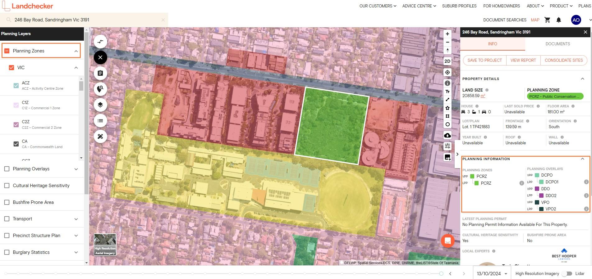
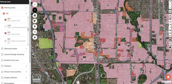
3. Planning Zones can also be activated and filtered on the map under the 'Planning Layers' on the left-hand side of the screen and selecting 'Planning Zones'.
Sign up today to access Land Zoning & Zoning Maps
Search addresses to find their land zoning information on Landchecker
All Property Reports downloaded from Landchecker also include a full summary of planning information relative to a property, including planning zones.
What does R2 zoning mean in NSW?
R2 Low Density Residential is a residential zone under the NSW Standard Instrument Local Environmental Plan (LEP). It permits single dwellings and typically allows dual occupancies and secondary dwellings (granny flats). What's permitted on any given R2 property depends on the local LEP and whether the site falls within a state-level housing policy area, which can expand the permitted uses.
NSW has different residential zones as outlined under the NSW Standard Instrument LEP, with each zone having a varied purpose and regulations.
R1 General Residential supports a mix of housing types and densities, including boarding houses, dwelling houses, attached dwellings, semi-detached dwellings, shop-top housing and residential flat buildings to provide the community’s housing needs and enable other land uses that provide facilities or services to meet the day-to-day needs of residents.
R2 Low Density Residential aims to maintain an area’s suburban character by permitting the development of centre-based child care facilities, single dwellings, dual occupancies and secondary dwellings like granny flats.
R3 Medium Density Residential provides a wider variety of housing types, such as townhouses, villas and terraces, to increase housing in areas with easy access to services and transport.
R4 High Density Residential allows the development of apartment buildings, shop-top housing and more intensive residential developments in urban areas close to public transport, employment centres, services and shopping precincts.
R5 Large Lot Residential allows large residential housing in rural or semi-rural areas while protecting and minimising the impacts on environmentally sensitive locations.
The Low and Mid-Rise (LMR) Housing Policy established by the NSW Government has expanded what's permissible in R2 low density residential zones located within an 800-metre walking distance of nominated train stations, metro stations, light rail stops and key towns. Permitted structures across R2 zones and designated LMR housing areas include dual occupancies and semi-detached homes. Multi-dwelling housing and residential flat buildings can be permitted with consent.
With these planning zone updates, it’s important to check both the local environmental plan (LEP) and any applicable state housing policy to confirm the land use zoning within a particular local government area (LGA), as policies vary by council and proposal.
You can also use Landchecker to view residential zones and NSW housing policy. Simply log in to your account and navigate to the planning layers on the left-hand side to toggle on the different layers available on the map.
What is Floor Space Ratio (FSR) and how is it calculated?
Floor space ratio is the gross floor area of a building divided by the site area. An FSR of 0.5:1 on a 600 sqm block allows 300 sqm of gross floor area. FSR is set by the LEP or planning scheme and caps the overall size of what you can build, regardless of how many storeys.
A 600 sqm site area multiplied by the floor space ratio of 0.5 gives you 300 sqm of permissible gross floor area where you can build a modest 4-bedroom home or a duplex split across two dwellings.
Gross floor area includes the area of a mezzanine, habitable rooms in a basement or attic and shops, auditoriums and cinemas in a basement or attic. However, it excludes terraces and balconies with outer walls less than 1.4 metres high as well as car parking.
It excludes any basement storage, basements with vehicular access, loading areas, garbage and services, or any spaces used for the loading and unloading of goods. Plant rooms, lift towers and other areas used exclusively for mechanical services or ducting do not count as gross floor area.
FSR is used in New South Wales, but equivalent controls exist in other states. Western Australia uses plot ratio, which is the ratio of the gross floor area of a building expressed relative to the site area and sets the building massing for a development site. Meanwhile, Victoria and Queensland use site coverage and height limits.
FSR can be combined with height limits and setbacks as primary development controls to create a building envelope. The building envelope acts as a guide to the approved area and building constraints within a property where development can take place.
Can I subdivide my block?
Whether you can subdivide depends on your zone, the minimum lot size set by your council and any overlays on the property. Subdivision pathways vary by jurisdiction and proposal type; some require a development application, while some limited scenarios (such as minor boundary adjustments in NSW) may proceed via complying or exempt pathways. Always check your council's specific requirements.
Zone, minimum lot size and overlays are three planning controls that determine subdivision potential. Zoning affects subdivision as it sets the land use and density limits allowed before subdividing a block. The next step is to check the permitted minimum lot size set out in the local environmental plan (LEP). Finally, planning overlays can influence how land can be developed with extra planning controls such as heritage, bushfire and flood that could restrict development beyond the zoning rules.
In addition to the planning controls, servicing (sewer, water, stormwater), existing easements, access/frontage requirements and site dimensions are some practical constraints that could also affect the feasibility of a subdivision.
The general process before subdividing land is similar across states. Start by applying for a development application and certificate of compliance unless it is exempt. Then, secure a survey approval through data allocation and from the Surveyor-General. Once approved, you can register the plan with the Land Titles Office (LTO) and await approval for the new title.
Each state has different fast-track pathways, so make sure to check locally. In NSW, the State Environmental Planning Policy (Exempt and Complying Development Codes) allows minor works or fast-tracked certification without a full local council development application (DA) for low-impact works, such as single or two-storey homes. In VIC, all new plans of subdivision lodged with Land Services Victoria are recorded under the Subdivision Act 1988.
The outcome of the new title matters since this could decide the planning approval rules, ongoing costs and property rights. Torrens title grants sole ownership of the land to the registered titleholder. A strata title separates ownership of individually owned units and the shared spaces in apartments and townhouses. Community title applies to ownership given to a specific home, building, or piece of land based on surveyed lines and shared common property managed by a body corporate.
Landchecker displays zone, lot size and overlay data in one map view, making it faster to assess subdivision potential before engaging a town planner or surveyor.
What is a BAL rating and bushfire-prone land?
A BAL (Bushfire Attack Level) rating measures the severity of potential bushfire exposure to a building. Ratings range from BAL-LOW (lowest) through BAL-12.5, BAL-19, BAL-29, BAL-40, to BAL-FZ (Flame Zone, highest). Higher ratings require stricter construction standards under AS 3959, which can significantly affect build cost and insurance.
| BAL Rating | Heat Flux Exposure kW/m² | What It Means for Construction |
|---|---|---|
| BAL-LOW | Insufficient risk to warrant specific measures | Over 40 kW/m², direct flame contact |
| BAL-12.5 | Up to 12.5 kW/m² | Basic ember protection — sealed gaps, ember guards on openings |
| BAL-19 | 12.5–19 kW/m² | Increased ember and radiant heat protection to external elements |
| BAL-29 | 19–29 kW/m² | Non-combustible or fire-resistant materials required on exposed elements |
| BAL-40 | 29–40 kW/m² | Flame contact possible; robust construction and fire-resistant glazing |
| BAL-FZ (Flame Zone) | Over 40 kW/m², direct flame contact | Most stringent AS 3959 construction requirements |
Bushfire-prone land is designated at the state/council level and displayed as a planning overlay across multiple states. If a property is located within a bushfire-prone area, it may require a site-specific BAL assessment. Areas with higher BAL ratings require specialised construction materials and design elements under AS 3959, such as non-combustible walls, roof vents fitted with ember guards with 2mm mesh and metal pipes for above-ground exposed water supply.
On Landchecker, go to the planning layer panel on the left-hand side and select the planning overlays to switch on the bushfire management overlays. You can also navigate to the hazards section to toggle on the bushfire option and check if your property is located in a bushfire-prone area.
What is greenfield development?
Greenfield development is the development of land that has not previously been built on, typically farmland, bushland, or vacant rural land on the urban fringe. It contrasts with brownfield development (redeveloping already-used land) and infill development (building within established urban areas).
Melbourne's Wyndham and Whittlesea growth corridors and Sydney's North West Growth Area are some examples of greenfield developments. Brownfields are previously used or developed sites such as Barangaroo, which is a former container terminal redeveloped into a mixed-use precinct. Infill sites are vacant or underused land in urban areas where duplex or townhouse projects can be built.
Greenfield lands generally go through several planning processes from the time they are categorised as either rural or agricultural, classified in a growth area ans included in a structure plan (which can be a Precinct Structure Plan for Victoria’s Urban Growth Zone and an urban release area for NSW), until they are eventually rezoned residential.
What does mixed-use zoning mean in Australia?
Mixed-use zoning permits a combination of residential, commercial and sometimes light industrial uses within a single zone. In Australia, it typically appears as Mixed Use Zone (VIC), MU1 under the NSW Employment Zones framework, or a Centre zone with mixed-use provisions in QLD councils.
The planning intent behind mixed-use zones is to provide a practical solution to urban planning challenges by having activated streets, reduced car dependency and 20-minute neighbourhoods.
What's typically permitted in a mixed-use zone are ground-floor retail or commercial buildings with residential apartments above, shop-top housing and small offices. However, a mixed-use zone does not overrule other planning controls such as height limits and FSR and residential uses above commercial still have to comply with amenity requirements around noise and ventilation.
The Housing Choice and Transport Zone (HCTZ) in Victoria extends this thinking by building housing at higher densities around activity centres and well-serviced locations, close to employment, services and public transport rather than relying on a standalone mixed-use zone.
State-by-State Frameworks
Every state and territory runs its own planning system with its own zone codes, instruments and terminology. A 'residential' zone in NSW carries different permissions to one with a similar label in VIC. This section covers the governing instrument, the main residential zones and one practical note per jurisdiction. Every state-specific claim links to the primary source.
New South Wales (NSW)
NSW uses the Standard Instrument LEP under the Environmental Planning and Assessment Act 1979. Residential areas are classified as R1–R5 residential zones (General, Low Density, Medium Density, High Density, Large Lot).
The 2022 Employment Zones Reform replaced the B-series with E1 Local Centre, E2 Commercial Centre, E3 Productivity Support, E4 General Industrial, E5 Heavy Industrial, MU1 Mixed Use, W1–W4 Waterway. Rural zones run through RU1–RU6, encouraging sustainable primary industry production by maintaining and enhancing the natural resource base. The Low and Mid-Rise Housing Policy is a recent overlay which permits dual occupancies and semi-detached homes in the R2 low-density residential zone across all of NSW.
Victoria
Victoria follows the Victoria Planning Provisions (VPP) under the Planning and Environment Act 1987. Residential land sits in the Neighbourhood Residential Zone (NRZ), General Residential Zone (GRZ), or Residential Growth Zone (RGZ), with the newer Housing Choice and Transport Zone (HCTZ).
Victoria's other land zoning categories are grouped into commercial, industrial, mixed-use and rural. Commercial land uses include Commercial 1, 2 and 3 zones. Industrial land uses include Industrial 1, 2 and 3. Rural Victoria is divided into the Farming Zone (FZ), Rural Living Zone (RLZ), Green Wedge Zone (GWZ) and Green Wedge A Zone (GWAZ), protecting Melbourne's non-urban fringe.
Queensland
Queensland has no single statewide zoning template. Each council writes its own planning scheme under the Planning Act 2016 and Planning Regulation 2017, so zone names and boundaries vary more between councils than in any other state.
In QLD, residential land is graded through Low, Low-Medium, Medium and High Density Residential zones. Meanwhile, activity centres are ranked through Principal, Major, District, Local and Neighbourhood Centre zones. Industrial land in QLD sits in dedicated Industry zones such as the Industrial Amenity Overlay.
Western Australia
The planning scheme for Western Australia falls under the Planning and Development Act 2005, though most people misinterpret R-Codes as zoning codes. R-Code is a density code such as R20, R40, or R60 applied to residential-zoned land, controlling minimum and average lot size, site coverage and setbacks. An R40 coding broadly indicates a density of around 40 dwellings per hectare. Unlike zones where there is only a zone code, residential land is assigned an R-Code that can be R20, R40 or R60 depending on the density of the zone.
South Australia
South Australia consolidated its councils' separate Development Plans into a single, statewide Planning and Design Code in 2021, made under the Planning, Development and Infrastructure Act 2016.
Residential areas are grouped into Neighbourhood, Suburban Neighbourhood and Urban Neighbourhood for established suburbs, Housing Diversity Neighbourhood for planned medium-density infill and Master Planned Neighbourhood for new greenfield communities, alongside more specific zones like Hills, Waterfront and Township Neighbourhood.
Commercial and industrial land sits under Employment and Strategic Employment zones, which distinguish light, low-impact business activity from heavier industrial, logistics and storage uses.
Tasmania
Tasmania consolidated its 29 council schemes into one statewide Tasmanian Planning Scheme, made under the Land Use Planning and Approvals Act 1993, with local variations layered in as a Local Provisions Schedule per council. Residential land sits in General Residential, Inner Residential, Low Density Residential, or Rural Living zones, graded mainly by density and lot size.
Commercial land runs across General Business, Local Business and Central Business zones. Industrial land runs through Light Industrial and General Industrial. Everything outside settlement boundaries typically falls under Agriculture, Rural or Environmental Management zones.
Australian Capital Territory
ACT’s planning system operates under the Territory Plan 2023 and the Planning Act 2023, with residential land graded RZ1 through RZ5 (from suburban lots up to high-density residential), commercial land across CZ1 to CZ6, industrial land in IZ1 and IZ2 and rural or environmental land under the non-urban NUZ zones.
In ACT, the Territory government is both the planning authority and the service provider, so there's a single plan and a single point of contact rather than a state framework filtered through dozens of council schemes.
Northern Territory
The Northern Territory Planning Scheme, made under the Planning Act 1999, divides residential land into three categories including Low, Medium and High Density Residential zones. Commercial activity sits in Central Business, Commercial and Service Commercial zones and industrial land is in Light Industry and General Industry zones, with a flexible Development zone for sites earmarked for future rezoning.
Zoning data on Landchecker is sourced from state authorities including Vicmap Planning, NSW Planning Portal, Landgate, ACT Government, LIST Tasmania and South Australia Planning Portal Authority. For QLD, planning zones are sourced from different council authorities such as Brisbane City Council’s City Plan. Landchecker’s zoning data is refreshed weekly. Last data sync: 4 August 2026.
Zones vs Overlays
A zone is the primary land use control on a property; it defines what the land can broadly be used for. A planning overlay is an additional layer of controls sitting on top of the zone, addressing specific concerns like heritage, bushfire risk, flooding, or environmental protection. A property can have one zone and multiple overlays.
The common overlays across Australia include Heritage Overlay (HO), Bushfire Management Overlay (BMO), Flood or Floodway Overlay (FO), Design and Development Overlay (DDO), Vegetation Protection Overlay (VPO), Environmental Significance Overlay (ESO) and Development Contributions Plan Overlay (DCPO).
For example, for a General Residential Zone (GRZ) property with a Heritage Overlay (HO), the zone permits demolition and rebuild, but the overlay requires council approval and can block demolition outright. Building on an area considered significant may require council approval for demolition, alterations or even a new fence. In short, the planning zone sets what's possible, while the planning overlay decides how much of the area or property you can develop or renovate.
On a zoning map, overlays are stacked on top of a zone. A property can have no overlays, one overlay, or multiple overlays layered above a single planning zone. For subdivision, development and valuation, overlays can change what's possible and what a property is worth, since having the right zone doesn't guarantee an easy outcome if an underlying overlay may still require additional permits or restrict what can be built on the site.
Understanding land zoning and using zoning maps effectively are essential for anyone involved in property transactions or development.
By providing comprehensive zoning data across Australia, Landchecker helps simplify this process, making it easier for users to access critical information, avoid potential pitfalls and make informed decisions.
Understanding land zoning and using zoning maps effectively are essential for anyone involved in property transactions or development.
By providing comprehensive zoning data across Australia, Landchecker helps simplify this process, making it easier for users to access critical information, avoid potential pitfalls, and make informed decisions.