Drawing Tools
"Landchecker allows us to stay on the front foot by accessing the most up to date data available."
David J Hall, National Director, Head of Brokerage L & I
Cushman & Wakefield
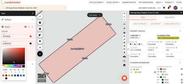
The Landchecker toolbar features various drawing tools that allow you to measure and annotate a property or land area from your desktop.
If you’re an architect or town planner, you can use the drawing tools to create site plans or conduct thorough feasibility analyses seamlessly.
Real estate agents, property developers, and legal professionals can use the drawing tools to conduct due diligence on a property or potential development site, drawing property boundaries straight on the Landchecker map.
On the right-hand side panel, you can use any of the following tools:
Text Label Tool - used to add annotations or labels on a property
Distance Tool - used to measure the length of a property or land area
Any Shape Tool - used to measure irregularly shaped objects with multiple points
Rectangle Tool - used to measure regularly shaped objects like pools or draw perfect right-angle shapes
Circle Tool - used to measure the area, radius and diameter of a property
After drawing a shape or adding text on the map, there are several ways to change their display attributes. Customers on the Advanced or Enterprise plan can customise the shapes via the Tools panel in the following manner:
Colour and opacity - of the fill and stroke of shapes
Rename - any shape to your chosen name
Display - toggle on/off the line length and area
Reorder - click and drag the shapes to reorder
Units - you can set the measurement unit to any of the following:
Metre (m/m²)
Kilometre (km/km²)
Feet (ft/ft²)
Yard (yd/yd²)
Miles (mi/mi²)
Nano Miles (nmi/nmi²)
Meanwhile, all members with a paid plan can delete and show/hide shapes. They can also access the Tools Settings to remove the bounding box. Check out our help article, which outlines the steps with screenshots for ease of reference.

You can also request a demo to learn more about how drawing tools can help you, or visit our Plans page to purchase access to drawing tools today.

What does my plan include?
Paid yearly Paid monthly | Starter Free | Standard | Advanced | Enterprise Contact Sales |
|---|---|---|---|---|
Additional cost per member | ||||
Property Information | ||||
... and many more | ||||
Map Views | ||||
ICEYE Flood Layer? | ||||
Metromap high resolution aerial imagery? | ||||
... and many more | ||||
Tools | ||||
Measuring tools? | ||||
Planning permit filtering? | ||||
Planning permit alerts? | 10 per member | Unlimited | Unlimited | |
Save properties to Projects? | ||||
Site Consolidation ? | ||||
... and many more | ||||
Documents & Reports | ||||
Title and Document searches? | ||||
Premium property reports | 10 per member | Unlimited | Unlimited | |
... and many more | ||||
Business Features | ||||
Credit terms available | ||||
... and many more | ||||
