
More places of interest and billing summaries
Places of interest (POIs)
Whether you're sourcing a site, pitching a vendor, valuing a property, or doing due diligence, context is everything.
To access it: Open Common Layers on the left-hand menu → toggle on Amenities.
Here's what's new:
🗂 More POI data points — expanded coverage from a new data source
🎨 Refreshed icon design — cleaner layers, easier to read at a glance
↕️ Drag to reorder — prioritise the POI layers that matter most to your workflow
Easily Track Your Order Costs Per Job
You can now receive a billing summary PDF attached to every order delivery email. It's an itemised breakdown of each order (job reference, property, date, and cost), making it easy to reconcile Landchecker orders against your own records or pass costs on to clients.
Site Finder - More filters and UX improvements
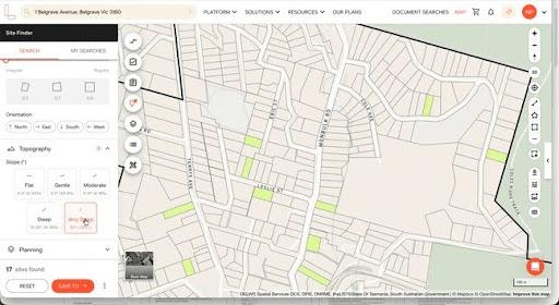
Finding sites with limited filters meant a lot of manual work just to get to a shortlist.
We listened to your feedback and updated Site Finder with more search criteria and a cleaner interface, so getting the right sites takes less time.
What’s New in Site Finder:
Additional Location Search — search by SA1 (a smaller geographic area than a suburb) in addition to suburb and municipality for tighter, more targeted results
Shape & Geometry — filter by lot shape and squareness factor when the physical configuration of a site affects how developable it is
Topography — filter by slope to rule out sites where the gradient makes development difficult and costly before you spend time on them
New Save Button — quickly save your site finder results to a Project or the My Searches tab
Favourite your most use Planning Layers and new Queensland data
Control How Planning Layers Appear on the Map
When multiple layers are active, like zones, overlays, hazards and easements, they can start to overlap, making the map harder to read. You can now adjust the opacity of each layer group using the slider in the Planning Layers panel.
READ OUR HELP ARTICLE FOR MORE DETAILS →
Brisbane Neighbourhood Plans and Other Local Plans Are Now Available
Brisbane now includes neighbourhood plans. This data sets character requirements, setbacks, and amenity provisions for specific suburbs and precincts.
We've also added local plans across Queensland, which apply to particular sites or precincts with their own development requirements.
Both are now mapped in Landchecker and accessible in three places:
Planning Layers panel (left-hand side)
Property information panel (right-hand side)
Downloaded property reports
New and improved UI, map interface and more Victorian data updates

Map style updates
The latest mapbox style has a number of new features including:
Highways
Footpaths
Terrain visualised
Improved visibility of road names
This along with the ability to increase the thickness of the cadastre makes viewing properties with and without high resolution much easier.
New themes
New branded light and dark themes can now be chosen under your profile menu including:
Light — the default, clean interface
Dark — easier on the eyes in low-light settings
System — automatically follows your device's display settings
Classic — the original Landchecker map style
User Interface Improvements
We have made a few changes to keep icons consistent and improve mobile experiences including:
New outlined icons, less obtrusive with subtle contrast to reduce eye strain
Drag up/down the property panel on mobile to access more of the map when viewing properties.
More data for Victorian properties
Updates to victorian planning data including:
New geospatial data set for VIC Activity centres, view clearer data on the map.
See what properties are in the pipeline to be titled with the Victorian proposed cadastre dataset. View on the map, in the property panel and via the address search.
Shortcuts and split view

Compare High-Res Aerial Imagery
Advanced and Enterprise members can now use a slider to compare high-res imagery of the same property taken on two different dates, making it easy to track changes to a site over time.
Learn How to Compare Hig-Res Imagery→
More Updates for Faster, Smoother Workflows
A few updates that'll save you time while using the platform:
Log in and press Shift + ? to see the list of new keyboard shortcuts
Use your arrow keys to flip through high-res aerial images quickly
Saving or creating a project is now simpler and quicker
Upgraded 3D Base Map Experience
We've updated our map to the latest Mapbox style. Enjoy a more modern, interactive, and visually enhanced base map with features like 3D buildings.
Speed up workflow with UX and data improvements
We've been busy. Here's a look at what's new – from a richer map experience to faster workflows and more data where you need it.
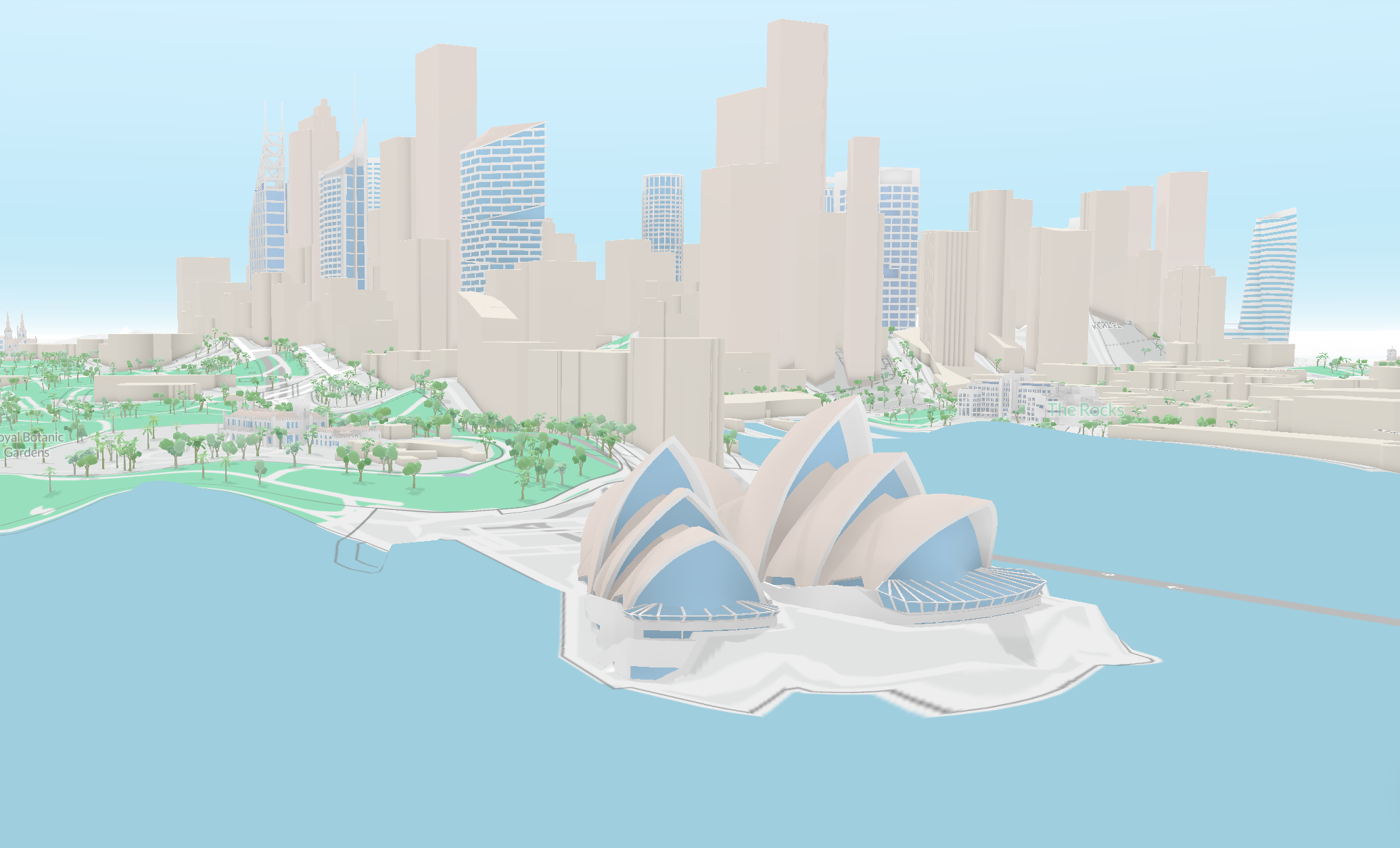
See the bigger picture with 3D buildings view
The Mapbox update brings 3D buildings to the map, giving you a clearer sense of the built environment in your city
Car parking requirements data now available
Victorian users can now access car parking requirements data via the planning layers panel.
Filter by label on the map
Narrow down what you're looking at with label-based filtering on the map. Find what's relevant to you, faster.
Search with more property identifiers
You can now search for documents using stare specific property identifiers, making it easier to find exactly what you're looking for.
Suburb profiles updated to 2021 data
Suburb profiles now reflect the latest 2021 census data, so you're working with the most current snapshot of the communities you're researching.
Two new hazard layers added
Acid sulphate soils and mine subsidence are now included in the hazards section – useful context for due diligence on properties.
A smoother, faster experience We've made some UX improvements to help you move through your work more efficiently. Use arrow keys to navigate through high-resolution images, and enjoy a streamlined create and save flow for projects.
Queensland overlays now available
✨ QLD overlays are here!
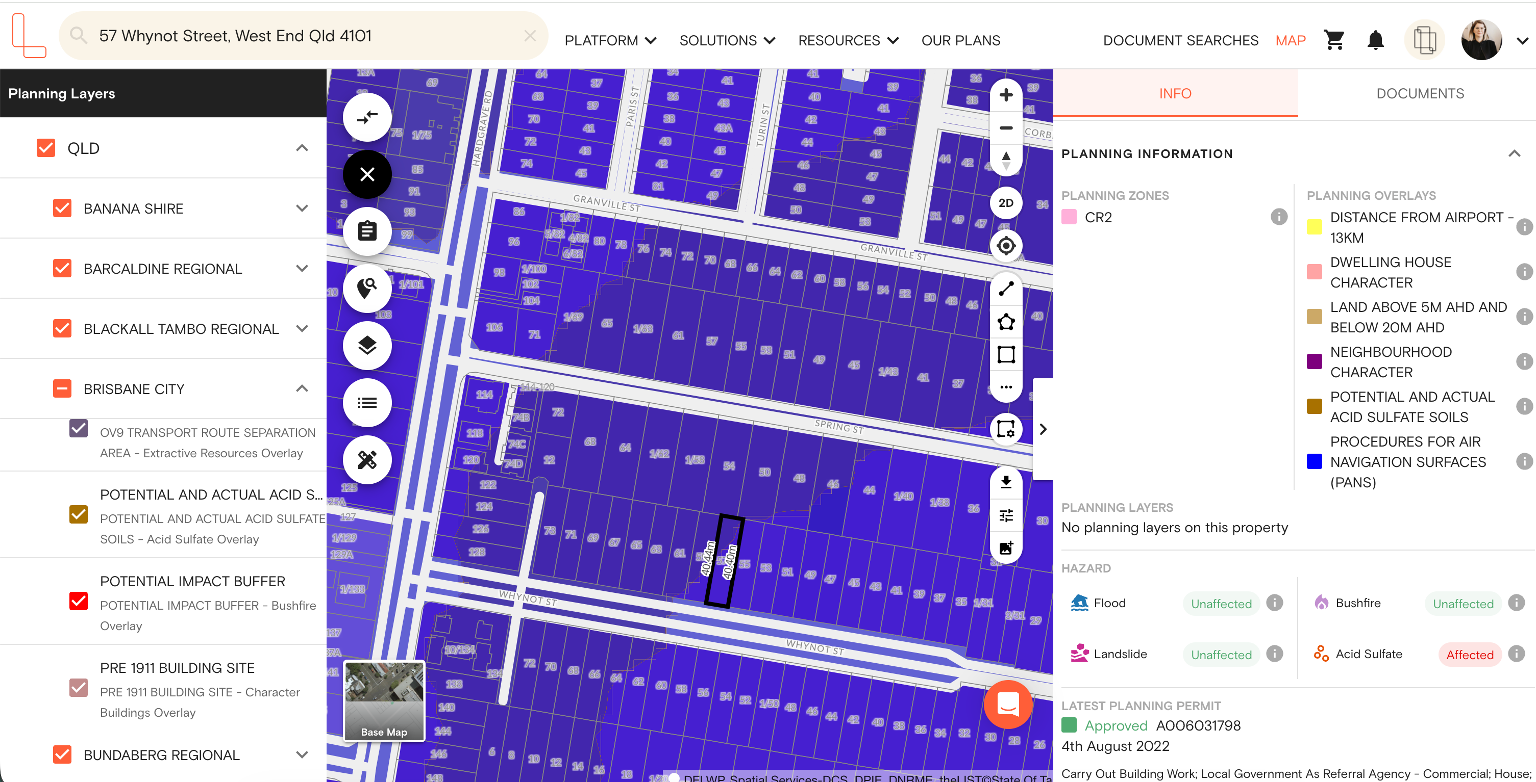
1.9M+ planning data points covering acid sulphate, flood, and bushfire are now available across 17 major councils in Queensland.
What's included: Brisbane, Gold Coast, Moreton Bay, Sunshine Coast, Logan City, Redland City, Ipswich, Toowoomba, Bundaberg, Gladstone, Mackay, and 6 other major councils.
Where to find it:
Planning layers (left panel)
Property information (right panel)
Premium Property Reports
Filter by labels is here
Here’s what's new in Landchecker early December 2025
Filter using labels in Projects
Advanced and Enterprise customers can now filter Projects in the Project Dashboard by labels.
Address Improvements
Properties with multiple addresses can now be searched using all addresses. View all known addresses on the property on the right hand side panel.