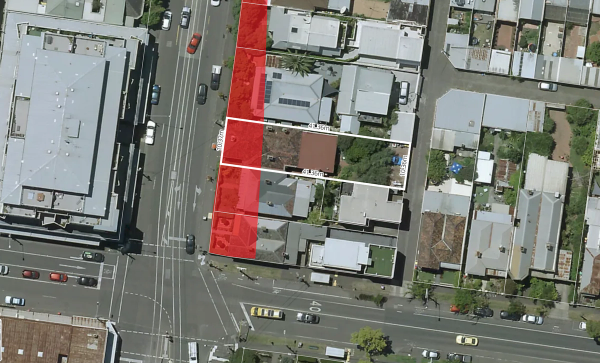
Public Acquisition Overlays in Victoria
In Victoria, public acquisition overlays (PAOs) are a planning tool used to reserve land for future public use. This can include infrastructure projects like roads, railways, schools, and parks. PAOs are an essential part of the planning scheme, indicating areas where the government intends to acquire land for public purposes.
Key Aspects of Public Acquisition Overlays in Victoria:
Purpose:
Reserve land for future public use and infrastructure projects.
Ensure land is available for essential public services and amenities.
Implementation:
PAOs are included in the local planning schemes and specify the type of public use planned for the land.
Affected landowners are notified, and the overlay is recorded on the land title.
Process:
Identification: The government identifies land needed for future public use.
Notification: Affected landowners and the public are informed about the PAO.
Acquisition: When the land is needed, the government proceeds with the acquisition process, which includes compensation to the landowners based on market value.
Rights and Compensation:
Landowners have the right to fair compensation for the acquisition of their land.
The compensation process is governed by the Land Acquisition and Compensation Act 1986.
Planning Scheme:
PAOs are part of the local council's planning scheme and are detailed in planning scheme maps and documents.
Examples:
Land reserved for new road projects, such as expansions or new routes.
Areas designated for new public schools or hospitals.
Spaces allocated for public parks or recreational facilities.
For specific information about PAOs affecting a particular area in Victoria, you can check the local council's planning scheme or contact the council directly. You can also access the Victorian Government's planning website for detailed maps and documentation regarding PAOs.

What does my plan include?
Paid yearly Paid monthly | Starter Free | Standard | Advanced | Enterprise Contact Sales |
|---|---|---|---|---|
Additional cost per member | ||||
Property Information | ||||
... and many more | ||||
Map Views | ||||
ICEYE Flood Layer? | ||||
Metromap high resolution aerial imagery? | ||||
... and many more | ||||
Tools | ||||
Measuring tools? | ||||
Planning permit filtering? | ||||
Planning permit alerts? | 10 per member | Unlimited | Unlimited | |
Save properties to Projects? | ||||
Site Consolidation ? | ||||
... and many more | ||||
Documents & Reports | ||||
Title and Document searches? | ||||
Premium property reports | 10 per member | Unlimited | Unlimited | |
... and many more | ||||
Business Features | ||||
Credit terms available | ||||
... and many more | ||||
