
Articles
QLD Flood Zones: What They Are and How to Check Them
Queensland is one of the most flood-prone states in Australia. Major river systems like the Brisbane, Fitzroy, Burnett and the Lockyer Creek drain vast inland catchments. While in the northern region of Queensland, the tropical climate is characterised by cyclone rains with little notice. When those systems flood, it affects thousands of properties and businesses.
The Queensland Reconstruction Authority (QRA) and local councils manage the flood zone mapping in Queensland. QRA coordinates the information from all hazards across the state. Detailed maps of flood awareness are prepared by individual council authorities, such as the Brisbane City Council.
What Are Flood Zones in Queensland?
Flood zones are areas of land in Queensland prone to flooding identified based on the modelled flood behaviour. Flood zones in QLD are a combination of various flood studies carried out in regional and local areas.
QRA is the state’s main agency responsible for disaster recovery and resilience policy. Their purpose is to coordinate action to improve the resilience of QLD communities and facilitate locally-led disaster recovery.
Local Council Flood Hazard Mapping
Queensland’s local councils are in charge of developing flood hazard maps. For example, Brisbane City Council has one of the most detailed flood awareness maps in Australia. This map was developed based on the local authority’s own modelling of the Brisbane River and Moreton Bay catchments.
The key terms used for flood mapping in Queensland
Flood hazard overlay: The overlay council uses for planning purposes. A development application must be subject to further scrutiny.
Annual Exceedance Probability (AEP): The probability of occurrence of a flood of a given size or larger in a given year. This is expressed as a percentage, such as the AEP of a flood event is 1% (or 1 in 100 years) since it has a 1% chance of being exceeded in a given year.
Design Flood Event (DFE): DFE is the minimum elevation a structure must be elevated or floodproofed. It’s the sum of the base flood elevation and freeboard. DFE is applicable when creating infrastructure design, during emergency management and risk assessment, as well as establishing land use planning.
Flood modelling: The process of simulating flood behaviour such as depth, extent and velocity on a computer using rainfall and the area's hydraulic characteristics.
Flood modelling is different from hazard maps since flood modelling uses hydrological data to simulate water flow in order ot predict flood behaviour.
Meanwhile, hazard maps are created after conducting flood modelling, and they are shown on a planning scheme overlay. In short, hazard maps are developed at a specific time, while flood modelling can be carried out at any time.
How QLD Flood Mapping Works
In January 2011, thousands of homes in Brisbane and Ipswich were flooded due to riverine flooding. The following year, in February 2022, there was a creek flow flood due to the intense and continued rainfall across many Brisbane suburbs.
With multiple floods happening each year, Queensland flood mapping uses flood studies from regional, local and historical flood events to ensure these events are well documented.
That said, with data available from different sources, the QLD government created a guide for flood studies and mapping to provide stakeholders with a more consistent result for flood studies and mapping within the state.
In February 2011, the government also launched the QRA to manage flood risk and disaster recovery. In this case, the agency also assists councils in flood studies.
In addition, the Brisbane City Council Flood Awareness Map dataset was launched in June 2013 to enable communities to view flood likelihood and overland flow impact. The platform also shows historical flood extents from 1974, 2011, and 2022, so users can compare flood scenarios within a specific area or property.
How to check QLD flood zones using Landchecker
Landchecker’s flood coverage includes 82% of the local councils or 77% of the population in Queensland, which is updated monthly. To check QLD flood zones using Landchecker, simply log in to your account and follow the instructions below.
1. Use the search box to find a QLD property. You can search by the complete address, coordinates, lot/plan details, locality, municipality or postcode.
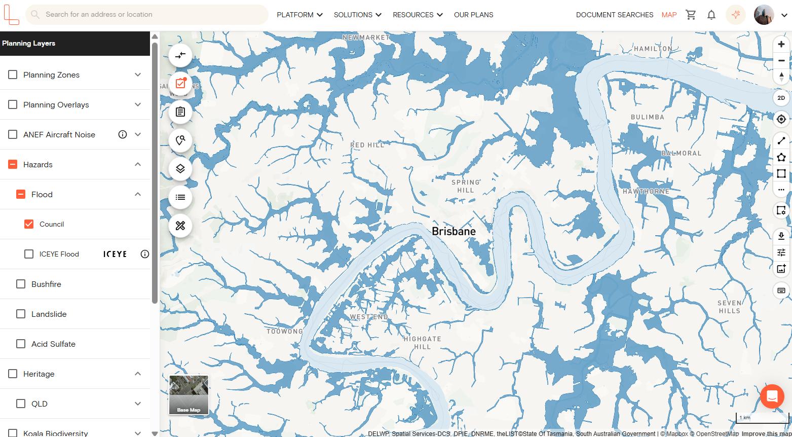
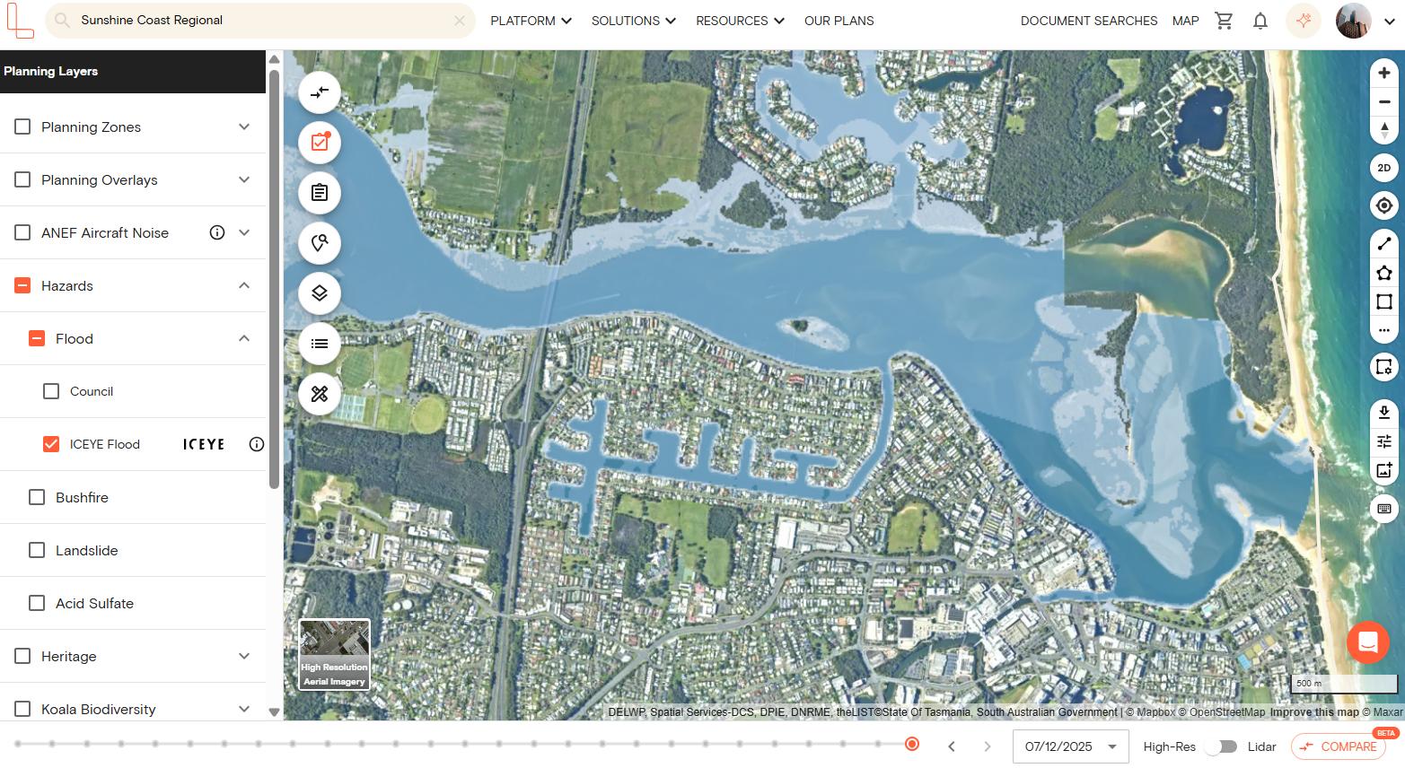
2. Click the planning layers icon on the left-hand side section. Scroll down and click the Hazards layer. This will show a dropdown option where you can select Flood.
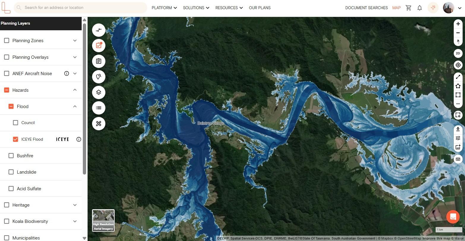
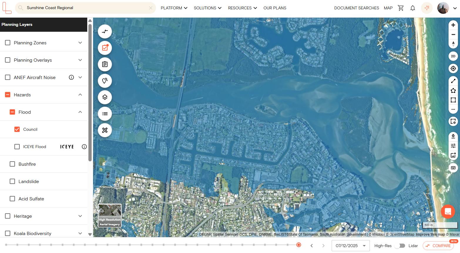
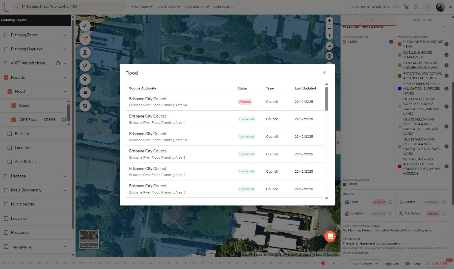
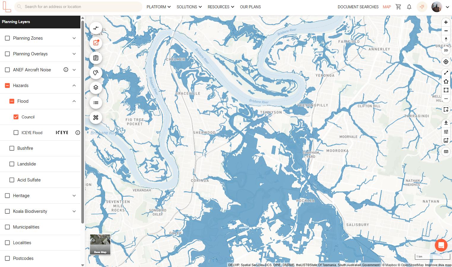
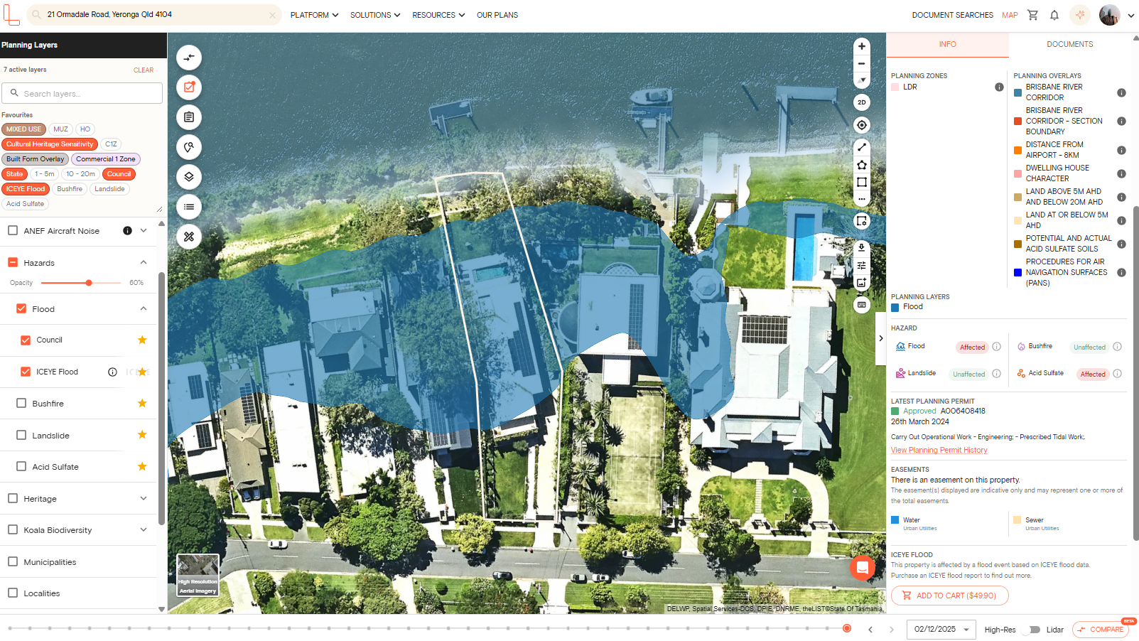
3. There are two flood layers available for QLD. You can select either the Council layer or the ICEYE flood data. You can also toggle both layers for a more comprehensive flood data.
4. If you selected the Council layer, you can refer to the right-hand side property information panel for more details regarding the source authority and when the flood dataset was last updated on our platform.
5. If you need a flood report for your specific property, you can click the "View Report" button on the right-hand side panel to download a premium property report.
If the property is affected by a flood event based on ICEYE flood data, you can buy a premium ICEYE flood report, showing historical Flood Insights outlining the impact of flood events and the flood depth of the event on properties within Australia.
Brisbane Flood Zones Explained
The Brisbane River catchment area drains a large amount of water into the Lockyer Valley and into the Bremer River. There has also been an increase in the number of flood zones along the Brisbane River and its creek beds. The high-risk river areas include Rocklea, Fairfield, Graceville, West End and New Farm.
Brisbane has created detailed flood modelling and the Flood Awareness Map, which can be accessed online. The map shows flood risk and the history of past floods. However, it does not show flooding in real-time.
The map shows flood probabilities in four categories: high likelihood (5% annual chance), medium likelihood (1% annual chance), low likelihood (0.2% annual chance) and very low likelihood (0.05% annual chance).
In addition to that, the flood awareness map provides flood impact from overland flow, which is a run-off that travels over the land during heavy rainfall events.
Brisbane has four types of flooding, including river, creek, overland flow and storm tide. This is why Brisbane City Council is considered to have a high search volume for flood zones, because users want to know what type of flood is actually occurring in that particular zone.
What Flood Zones Mean for Property and Insurance in QLD
Properties with higher flood risk have higher insurance premiums. Insurers have the option to offer flood coverage or have it as an option for clients.
Insurance companies also need to consider QLD’s standard definition of a flood, which was introduced in June 2012, when offering premiums. There are different factors to consider, so it’s important to check what your insurance policy covers before you make a claim.
For property developments, the Queensland Development Code (QDC), specifically MP3.5 sets the requirements for the design and construction of buildings in flood hazard areas, which aims to increase a property’s resilience to flood events.
What to do if a QLD property is flood-prone
Here are steps you can take to mitigate risks if you are buying, owning or developing a property located in a flood zone.
1. Get a property-specific flood report from your local council
Most councils in Queensland offer a free or paid flood report for individual properties. If your property is in Brisbane, you can generate a FloodWise property report on their flood awareness map online.
The report provides flood planning information. The report also uses City Plan’s adopted flood planning information, which guides how land is used and developed for the future.
2. Review QRA hazard maps for safety, insurance and property value
QRA designs, analyses and maintains different maps to support decision-making for disaster recovery and resilience. These maps include a map of disaster funding activities, which you can search by disaster year, event, council, eligible recipient or assistance measure.
You can also access the Repeat Events and Dollars Index (REDI) map, which helps councils better understand their risk, costs and repeat damage from natural disaster events.
Finally, you can access the local knowledge maps, which is a suite of catchment maps that capture extensive local knowledge of the dynamics of the catchment landscapes in South West and Central West Queensland.
3. Clarify insurance before signing a contract
Get multiple premium quotes from at least two to three insurers before exchanging and signing contracts related to a flood-prone property. It’s also important to confirm if they cover floods, not just storms.
4. Consider building modifications to reduce damage, insurance costs and safety risks
If you're a building industry professional, state and local authority or homeowner with a property in a flood-prone area, consider building modifications following the Flood Resilient Building Guidance for Queensland Homes to minimise damage caused by floodwaters.
5. Engage a surveyor/engineer for advice and assess risks
If you are building or renovating a property in a flood-prone area, hire a licensed surveyor to conduct a flood risk assessment and flood zone elevation survey to assess the possible damage a flood may cause.
An engineer can also help review site levels and finished surface grading, as well as manage overland flow paths.
QLD Flood Zone FAQs
How do I check flood zone by address in QLD?
Use Landchecker to check flood zones by address in QLD and view multiple council flood data in one place. Simply log in to your Landchecker account, search for an address and toggle on the flood layer under hazards on the left-hand side planning layers menu.
You can also visit your local council’s flood mapping tool, if available. There are local councils in QLD that manage their own flood mapping data, such as Brisbane City Council's Flood Awareness Map.
What is the Brisbane flood map?
The Brisbane flood map, also known as the Flood Awareness Map, provides flood information for your address, lot plan, suburb and surrounding area, including any local histories that extents from 1974, 2011 and 2022.
It’s a free online tool managed by the Brisbane City Council which also offers the FloodWise property report showing the defined flood level applicable to a specific property.
How accurate is QLD flood modelling?
The accuracy of the QLD flood modelling depends on the date the flood study was completed and the investment that was put into it. The Brisbane flood modelling is said to be among the most detailed models due to the level of gauge data, the marking by a surveyor and the history of floods that have occurred in the area. The rural areas may not have such detailed models.
Does flood risk affect home insurance in QLD?
Yes, flood risk affects home insurance in QLD. Since insurers use government flood mapping data as well as their own risk modelling to price premiums, properties located in higher flood-risk areas pay more than other property owners. Other insurers may exclude flood cover or only offer it as an optional add-on.
Are 2011 & 2022 floods represented in maps?
The January 2011 and February 2022 floods are represented in the Brisbane City Council’s Flood Awareness Map. It also displays the January 1974 flood. You can also learn more about these flood events under their definitions tab, where they explain the flood event and flood depth.
What is the QRA?
Queensland Reconstruction Authority (QRA) is the state’s main agency responsible for disaster recovery and resilience policy. Their purpose is to coordinate action to improve the resilience of QLD communities and facilitate locally-led disaster recovery.