Property Planning Maps
"Landchecker has provided significant support to our due diligence process, providing efficient searching solution and quick access to key planning data and high-resolution imagery. It’s an essential tool improving the efficiency of our opportunity assessment."
Roy Hu, Senior Analyst
Castle Group
Landchecker provides seamless property planning maps as a tool that can be utilised by people working in many different professions as a source of reliable planning information. The data that Landchecker provides is your resource for making faster and insight-driven decisions. In addition to our property planning maps, Landchecker also provides other data-driven tools such as property reports, zoning maps, property boundaries, and much more.
What are planning maps?
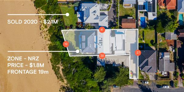
Planning maps are visual representations of selected properties or areas that showcase land and ownership information, amongst other data. In addition, Landchecker’s planning maps detail property information such as land size, planning zones and overlay information. Landchecker is one of the only applications where our planning maps are displayed with additional layers such as high-resolution imagery.
What can you do with planning maps?
Regardless of your industry or interest, there are a multitude of functions that you're able to use within a planning map.
Due to Landchecker's unique web application, you can configure your specific planning map and efficiently share a property report in a PDF to colleges, business partners or those with a vested interest in the work, making workflow such as council approvals easier to navigate by understanding what’s been approved in the area.
When you use our online planning maps, you'll have seamless and readily available access to elements such as planning permits, heritage listing and zoning information. By using the Landchecker tool, you can make informed decisions on your next or existing property project. All the data you need is located in the one-source, which is fast, accurate and above all easy to use.
Why are planning maps useful?
For those interested in property development, such as developers, architects, or town planners, a planning map is your much-needed tool when working with council members and ensuring your submissions have the best chance of being by understanding what’s been approved in the area. In addition, our planning maps are online, so when you work collaboratively with other property professionals, architects and anyone else involved in a project, you can easily view and share your planning map with detailed property information whilst creating specific projects.
For homeowners or property investors, you can see if the proposed location of your new home or property investment is right for you based on the rich data enabled on your map. Some features include information on pending new development applications or permits, or for those who have children, Landchecker will also display all the nearby schools local to the property in question. If you’re considering building a home, you can also get a view of any digitised easements that may be present. With this powerful information at hand, you’re able to make an informed decision on the land you’re looking to purchase or develop.
Planning maps specific to your state
Due to each state being unique and having varied property and council rules, Landchecker has sourced data for the following states.
Victoria
Discover your planning map for Victoria. One of our customers favourite features that is widely used in Victoria is the ability to identify areas which carry a heritage overlay. Many inner city suburbs have restrictions on changes to the facade or structure of a property which may not suit your next property purchase. Having this information available quickly can allow you to make fast decisions on if a property in question is right for you.
New South Wales
In New South Wales, we've recently seen one of the worst flood levels in the country's history. Landcheckers' online planning maps and tools have begun to create and roll out digitised property-level flood mapping data allowing prospective homeowners, buyers and sellers in flood-prone regions to understand flooding risks.
South Australia
Adelaide is filled with properties consisting of residential, commercial and industrial through to the quaint suburbs to the rolling Adelaide hills. Landchecker has gathered all the data in all of these areas, providing you with the information you need to find the perfect spot to settle.
Queensland
The sunshine state is known for its beautiful weather and warm climate. If you are a resident in Queensland or looking to invest due to their low stamp duty costs, we’ve gathered all the data you need to make a forward decision before establishing yourself in Queensland.
Western Australia
Landchecker provides online planning maps from residential areas, serene landscapes and amazing beaches. Having visibility into the R codes within Western Australia helps you plan your property project saving time by easily viewing them overlayed onto the planning map.
Tasmania
Tasmanian property has continued to grow at pace since the pandemic. With its natural beauty and some of Australia’s best produce you can easily review the hotspots and overlay planning zones and High-Resolution Aerial Imagery to inform your property decisions.
All these states have data available, with data from ACT coming soon to Landchecker.
How is this data sourced?
All data displayed by Landchecker has been procured from hundreds of different trusted sources. This includes state government, local councils and our partners such as PropTrack (owned by REA), RACV and Metromap. The data used is monitored and refreshed on a daily basis to ensure that it matches the source data. Landchecker has used all this readily available data to create convenient property planning maps and tools.
What specific data is displayed?
With Landchecker, you can view relevant data based on one of our plans tailored to you and your needs. Using our planning maps online, you’re able to complete a map-based search from your desktop, phone or tablet , with seamless access to other data sets for any property or site within one source. Depending on your plan, you’ll be able to access the following data,
Planning Information
Development Applications (DAs) and or Planning Permits
Site boundaries
Land size and dimensions
Proptrack sale history
Number of bedrooms, bathrooms and other property attributes
Recent and historic planning permits
Easements
Nearby Schools
Municipalities
Localities
Postcodes.
Why choose Landchecker for planning maps?
Landchecker is an up-to-date and accurate all-in-one source of property information.
With almost every state in Australia covered for property and land, Landchecker provides a seamless experience through user experience and available data. You can filter through our search functions to visualise your areas of interest.
Landchecker partners with MetroMap to provide low altitude High-Resolution Aerial Imagery in key population centres across Australia providing both historical imagery and with additional captures 4 times a year in metro and twice yearly in rural areas.
If you’re interested in using Landchecker for business or personal interest, discover our plans or get in touch with our team to further discuss the possibilities of Landchecker.