
Planning Permit Search & Development Application Filters & Alerts
Check local approved and rejected permits/DA's to get a feel for what's going on in the vicinity. Use our permit/DA filters to filter by keywords such as 'subdivision' and 'multi-level' to see what local council has approved nearby. View our coverage map today to see if we show permits/DAs in your area.
Filter By The Following Criteria
Approved, pending, rejected or other
Date received range
Outcome date range
Keyword
Alerts Can Be Set Up By The Following Criteria
Area - up to 1000m from subject property
Area - entire suburb
Filter by keyword
Choose the frequency you would like to receive the alerts.
How to view and filter planning permit information
Watch the video or follow the step-by-step instructions to find out how to view and filter planning permit information (development applications) in Landchecker.
Planning permit information is notoriously challenging to access, as each local council has its own way of sharing and displaying this information. Landchecker brings all this permit information into one place making it significantly faster and easier to access.
1. Turn on the planning permit layer
Click on the clipboard icon in the menu on the left side of your screen. Select ‘Planning Permits’.
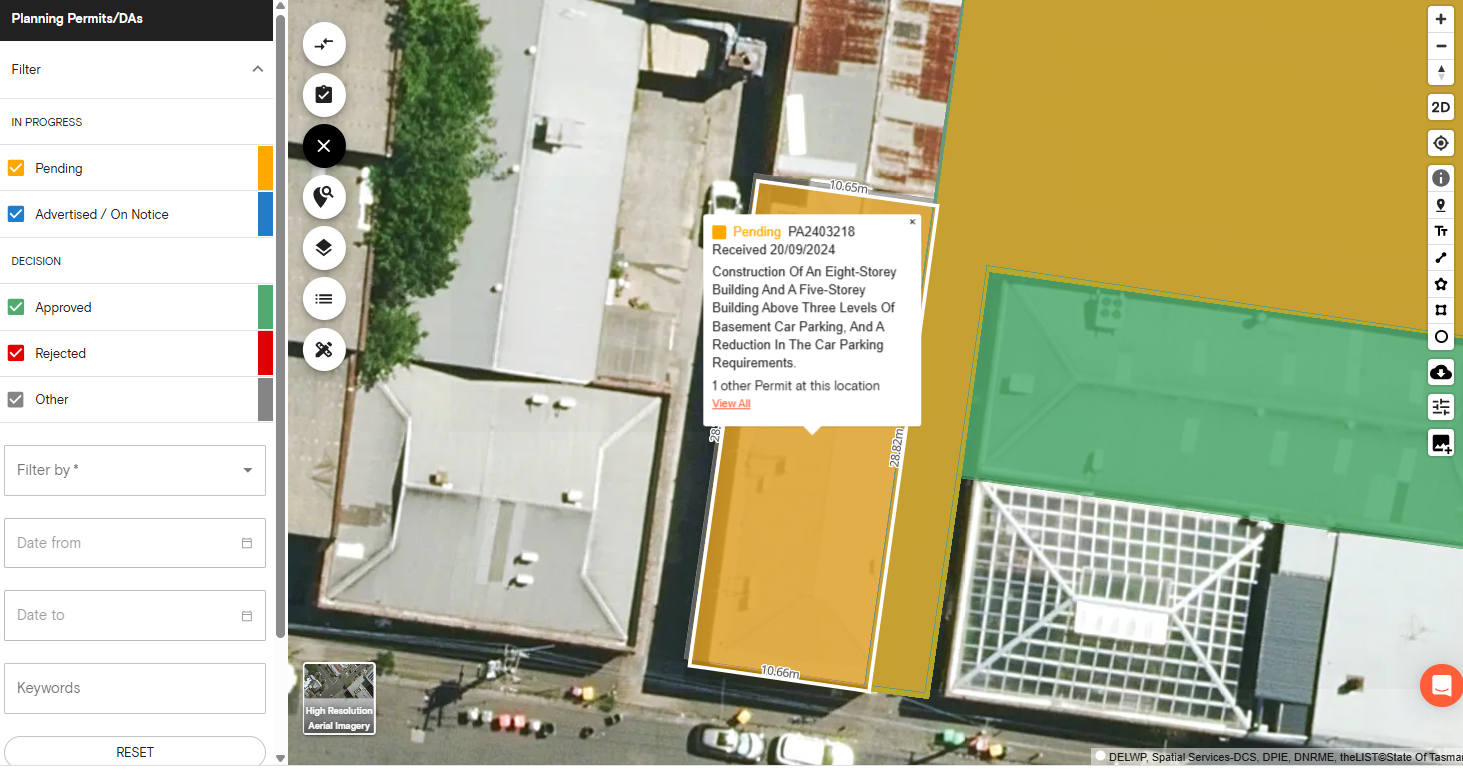
2. Hover over a property to view the planning permit information
The most recent permit is visualised with a traffic light system. Green for approved, orange for pending and red for rejected.
Hover over a property to view information on the permit. If there are historic permits on the property, you will see a link to View More.
3. Apply filters to find the relevant permit information
You can choose to filter the data by the date the permit application was received or the outcome date.
There are a number of different uses for this information depending on your industry. A Real Estate Agent may use this information to look for listings opportunities. An Architect or Town Planner may use the filters to look for planning permit precedents.
Permit & Development Application Filtering
Permit and Development Application (DA) filtering plays a pivotal role in the Australian property and construction landscape, offering significant advantages to professionals, property developers, and regulatory authorities.
Navigating the complex web of local regulations and planning requirements is essential for successful property development. Permit and DA filtering tools are tailored to the unique regulatory environment in different states and territories, such as New South Wales, Victoria, Queensland, and others.
Types of Permit & Development Applications
Common types of Permits/Development Applications include residential applications for new homes or extensions, commercial applications for businesses and retail spaces, industrial applications for manufacturing or warehouse facilities, and mixed-use developments combining residential, commercial, or industrial uses.
Ministerial Permits in Victoria
Ministerial permits are a type of planning permit issued by the Minister for Planning for large-scale developments exceeding 25, 000 square meters, such as the Melbourne Showgrounds or Flemington Racecourse.
Ministerial permits are also needed for specific areas in the Alpine Resorts, French Island, Sandstone Island, Elizabeth Island, Central Geelong Port of Melbourne, Port Phillip, Central Dandenong, and Kew Residential Services in Boroondara.
The Minister for Planning is also responsible for making decisions on applications for:
Renewable Energy Facilities
Non-Government Schools
Housing By Or On Behalf Of Homes Victoria (Clause 53.20)
Victoria’s Big Housing Build (Clause 52.20)
Development Facilitation Program Eligible Projects
Use Landchecker’s Permit/DA filters to see what ministerial permits the Minister for Planning has approved nearby. There’s also an option to filter by keyword, such as ‘ministerial’ to focus your search on relevant permits.
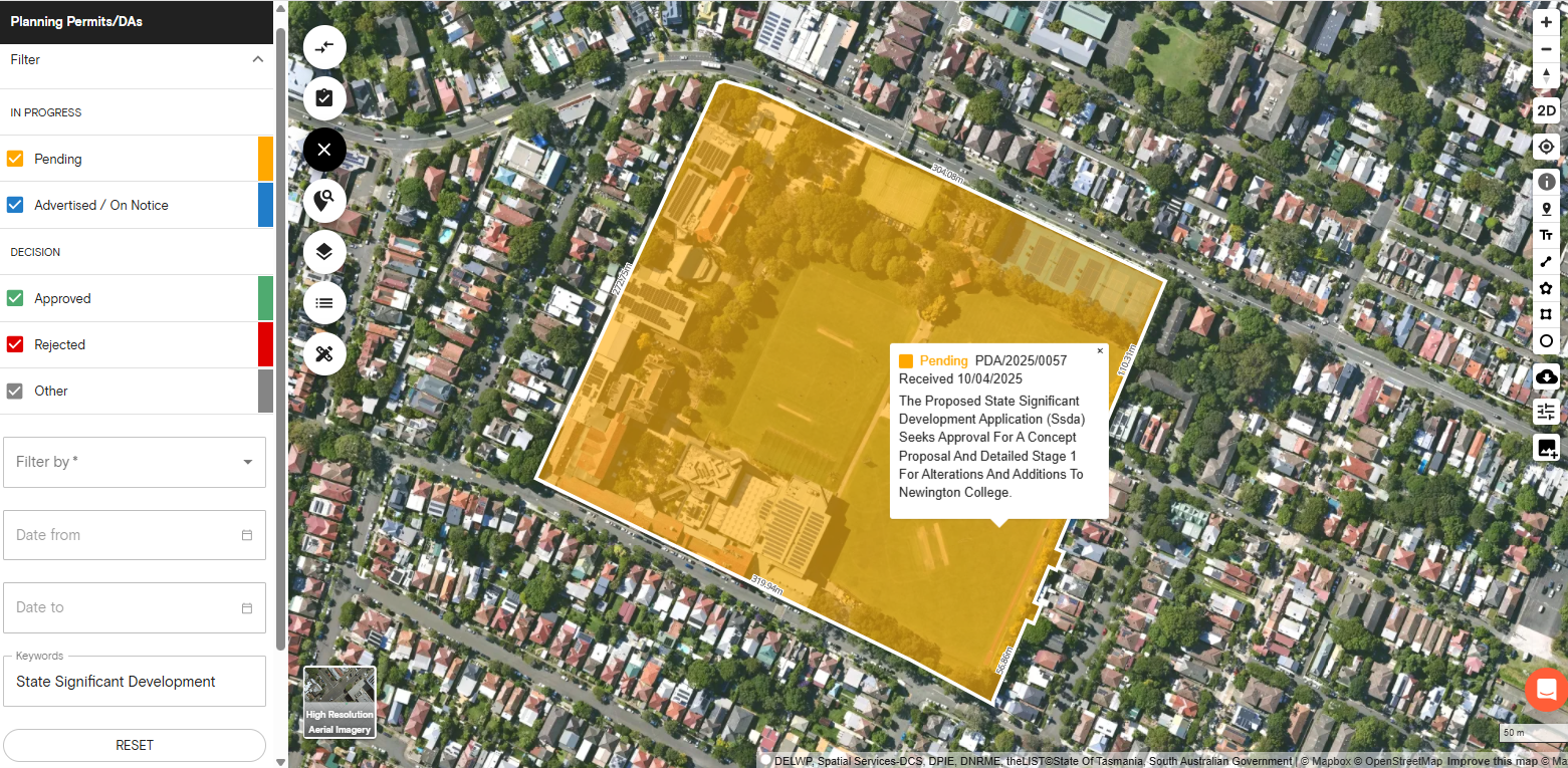
State Significant Development (SSD) in New South Wales
State Significant Developments (SSD) are projects important to New South Wales for economic, environmental or social reasons. The types of SSD projects include:
New educational facilities, hospitals and correctional centres
Manufacturing facilities
Tourist and recreational facilities
Waste management facilities
Energy generating facilities
Port facilities
Chemical industries
Mining and extraction operations
The Minister for Planning may also declare a development to be SSD by the order published in the Government Gazette after getting advice from the Independent Planning Commission.
View proposed, approved and rejected SSD applications on the Landchecker platform using the Planning Permits/DA filter.
Permit & Development Application Process
The application process typically involves several steps:
Pre-Application Consultation: Engaging with local authorities to discuss the proposal and obtain initial feedback.
Submission: Providing detailed plans, environmental assessments, and other required documentation.
Public Notification: Informing the community about the proposal, allowing for objections or support.
Assessment: The local planning authority reviews the application against relevant planning policies, guidelines, and community feedback.
Decision: The authority approves, modifies, or rejects the application, often with conditions attached.
Post-Approval: Complying with any conditions and obtaining necessary permits before construction begins.
This structured process ensures developments align with community standards and regulations.

What does my plan include?
Paid yearly Paid monthly | Starter Free | Standard | Advanced | Enterprise Contact Sales |
|---|---|---|---|---|
Additional cost per member | ||||
Property Information | ||||
... and many more | ||||
Map Views | ||||
ICEYE Flood Layer? | ||||
Metromap high resolution aerial imagery? | ||||
... and many more | ||||
Tools | ||||
Measuring tools? | ||||
Planning permit filtering? | ||||
Planning permit alerts? | 10 per member | Unlimited | Unlimited | |
Save properties to Projects? | ||||
Site Consolidation ? | ||||
... and many more | ||||
Documents & Reports | ||||
Title and Document searches? | ||||
Premium property reports | 10 per member | Unlimited | Unlimited | |
... and many more | ||||
Business Features | ||||
Credit terms available | ||||
... and many more | ||||


