
Property & Land Boundaries
Landchecker is your key to making data-driven decisions at any stage of your property venture. All of the Landchecker tools have been created for professionals, however are also very useful for anyone with a vested interest in property and land. When you use Landchecker, you can rest assured that our data sources are reliable, accurate and up-to-date.
The team at Landchecker works in harmony with our partners. This results in our data and applications staying updated to the latest advancements in technologies, ensuring our tools and capabilities are market leading. As a result, we provide you with relevant information that helps you make informed decisions on your next property move.
Due to the vast amount of data in our arsenal, Landchecker also offers other tools and features, such as land zoning maps, property planning maps and property reports.
What are property & land boundary maps?
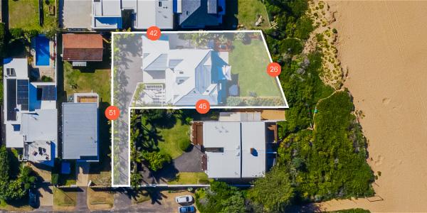
Property and land boundary maps give the outline of where the borders of different states, regions and properties exist. These land boundaries define who owns what property. Land boundary maps can extend past regions and into states, outlining the land ownership and where the land's boundary lines extend.
Who uses them and why are they useful?
Utilising a land boundary map is critical for anyone trying to develop or understand what property they own or are seeking to acquire. In addition, for those looking to develop the property or further expand developments, a land boundary map will outline where you may be able to subdivide and where exactly you can build. As Landchecker is an all-in-one tool, this is an advantageous and helpful option when going through this process.
If you're considering a renovation or extension in any state, having a land boundary map will give you the tools to aid in decision making.
What information do they show and how is that data displayed?
A property boundary map will outline the property boundary lines and site dimensions. This data is displayed clearly with an overlay over the top of a map of the allocated area. All of our property tools are easy to use and digest the relevant information. Landchecker has a dedicated team to ensure the data you need is displayed conveniently and easily.
Property boundary maps specific to your state
When needing to understand where property boundaries sit within your state, Landchecker can provide you with this information quickly and conveniently. As each state is home to its unique property boundaries, Landchecker gives you the information you need, tailored to your area of interest.
Property Boundary Maps New South Wales
In a state like New South Wales with the recent worst flooding in the country’s history, Landchecker provides you with the information about where your property extends to. Use the data given to make informed property and land decisions, ensuring where you choose to locate yourself or your next business venture is in a safe and viable location.
Property Boundary Maps Victoria
A state rich in its heritage, property boundary maps in Victoria are your key to ensuring you make a data-driven decision on your next property acquisition or renovation. Whether choosing between the suburbs or the outskirts, a property boundary map is another way to assist you when making the right decision of where you want to focus your property search.
Property Boundary Maps Queensland
Lush Queensland is covered on Landcheckers’ property boundary maps. With Landchecker’s property maps for Queensland, you can reveal fundamental lines and boundaries for different properties and areas.
Property Boundary Maps South Australia
South Australia has a wide variety of terrain and landscapes, and when looking for your next property, using a Landchecker property boundary map will outline exactly where the property you’re investigating begins and ends. Gain relevant information for an upcoming property purchase or renovation before investing.
Property Boundary Maps Australian Capital Territory
Similar to Queensland, the Australian Capital Territory is full of bushland and greenery. Your land boundary map with Landchecker gives you insight and knowledge to make an informed decision about where you settle and even discover areas that you can decide to avoid. In addition, you can see the distinct lines that make enquiring about property simple.
Property Boundary Maps Tasmania
With property boundary maps in Tasmania, you’re able to uncover what is beneath the serene landscape and see where the property boundary of the property you’re viewing starts and finishes. A property boundary map gives you transparent information to discover the best locations for you, and provides the tools you need to ensure you select the best piece of land to purchase or invest in.
Why choose Landchecker for property & land boundary maps
Landchecker’s property and land boundary maps give you an overview of the exact property borders relevant to the property you’re viewing displayed on a map. By understanding the exact borders of a property, You’re able to make informed property and land based decisions. All of our information provided is accurate, up-to-date and in one convenient place. You won’t need to chase up various councils for maps and information.
At Landchecker, we utilise High-Resolution Aerial Imagery, which is taken from national satellite coverage. By doing this, we’re able to provide you with clear imagery in all metro areas.
When you use Landchecker for our land boundary maps, you’re using the tools the professionals use daily. Our tools are trusted within the industry and provide a sound and necessary part of a property decision-making process.
If you think a land boundary map is what you need to start your property or development journey, get in touch with our friendly team to discuss the plans and options tailored to you.

What does my plan include?
Paid yearly Paid monthly | Starter Free | Standard | Advanced | Enterprise Contact Sales |
|---|---|---|---|---|
Additional cost per member | ||||
Property Information | ||||
... and many more | ||||
Map Views | ||||
ICEYE Flood Layer? | ||||
Metromap high resolution aerial imagery? | ||||
... and many more | ||||
Tools | ||||
Measuring tools? | ||||
Planning permit filtering? | ||||
Planning permit alerts? | 10 per member | Unlimited | Unlimited | |
Save properties to Projects? | ||||
Site Consolidation ? | ||||
... and many more | ||||
Documents & Reports | ||||
Title and Document searches? | ||||
Premium property reports | 10 per member | Unlimited | Unlimited | |
... and many more | ||||
Business Features | ||||
Credit terms available | ||||
... and many more | ||||


