Landchecker For Real Estate Agents
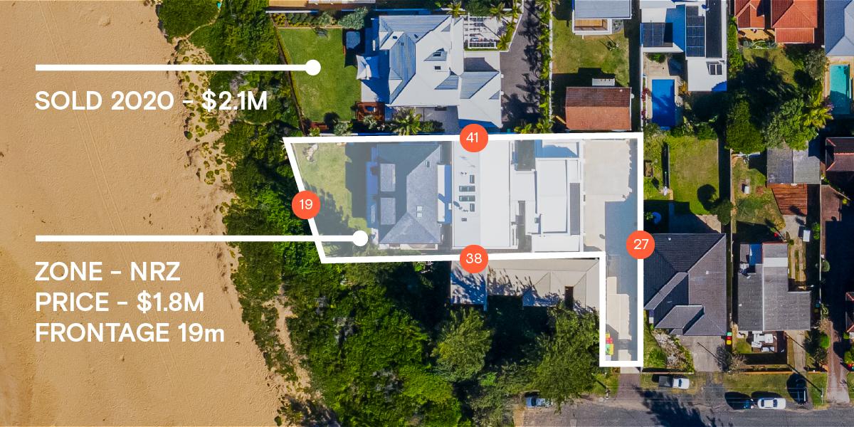
Get ahead, with reliable property data and market-leading tools

Planning Permits/DAs
Site Finder Advanced Search
Property Data
High-Resolution Aerial Imagery
Title and Document Searches
Premium Property Report
Projects
Planning Permits/DAs

Find new listing opportunities before anyone else
Find out about new developments and subdivisions as soon as the planning permit is submitted and set up alerts on properties or suburbs so you never miss an opportunity again.
View a consolidated planning permit database, and apply filters such as data status and keyword to bring listing opportunities to the surface.
Site Finder Advanced Search

Discover the potential in each suburb
Narrow down an entire state to a handful of suitable sites in seconds using advanced filters including suburb or multiple suburbs, land size, orientation, frontage, zones and with/without overlays.
Find suitable sites for clients, locate similar properties for under-bidders or prospect for properties with development potential.
SEARCH THE FOLLOWING CRITERIA
By single or multiple localities, postcodes and/or municipalities.
By land size range
Include properties within a zone
Include properties within an overlay
Exclude properties with an overlay
Orientation
Frontage range
Property Data

Property data in one place – for faster, insight-driven decisions.
Gather data to promote your listing, such as land size, planning zone, public transport options and amenities within a 10-minute walk, bike, or drive.
Measure areas of interest, or check the historical sale prices, all in one place.
High-Resolution Aerial Imagery

Showcase a listing from above to offer a different perspective
Export a high-resolution aerial photograph of a property. This is a great way to showcase how a property is situated within a site or the proximity to services.
Imagery is updated 3-4 times a year in metro areas and is captured from a plane, resulting in photographs 6x higher resolution than the best available satellite image.
CLEARER, MORE ACCURATE IMAGERY
Imagery is captured from a plane flying at a low altitude, resulting in photographs 6x higher resolution than the best available satellite image.
Overlay property information such as land size, planning zones and overlays.
Measure areas of interest.
Export professional-quality jpeg images.
SEE CHANGES OVER TIME
Browse extensive historic aerial imagery to understand how areas have changed over time.
New images are available three-four times a year in metro areas.
Title and Document Searches

Enjoy faster searches
Seamlessly search for competitively priced property documents including titles, copy of plans, instruments and company searches directly from the Landchecker map.
Easily manage team member permissions and view previously searched documents in the order manager.
DESIGNED FOR BUSINESSES
Order any property documents relating to your subject property directly from the Landchecker map.
Instantly receive titles by email or view documents in the Order Manager.
Assign a Job Reference to each search for invoicing purposes.
Assign permissions per user.
PROPERTY DOCUMENTS INCLUDING LAND TITLE SEARCH
Request all your property documents through Landchecker. Search by address, council number, crown descriptions, lot/plan or SPI.
Register search statement (Certificate of Title)
Historical Title search
Instrument search
Final search
Copy of plan
Company search
Premium Property Report

Build buyer confidence with an easy-to-read report
As a trusted advisor, distribute a comprehensive, easy to read property report to prospective buyers branded with your company logo.
Property Reports contain all the data from the Landchecker map view, distilled into a simple report.
DESIGNED FOR BUSINESSES
Order any property documents relating to you subject property directly from the Landchecker map.
Instantly receive titles by email or view documents in the Order Manager.
Assign a Job Reference to each search for invoicing purposes.
Assign permissions per user.
PROPERTY DOCUMENTS INCLUDING LAND TITLE SEARCH
Request all your property documents through Landchecker. Search by address, council number, crown descriptions, lot/plan or SPI.
Register search statement (Certificate of Title)
Historical Title search
Instrument search
Final search
Copy of plan
Company search
Projects

Build a database of properties to use as a business wide conflicts check
Save properties of interest to projects for future reference, add notes to a project or property, add documents and export results.
Save Site Finder results to projects and securely share projects with team members to collaborate and speed up work-flow.