Company News
New South Wales Flood Data Update
The recent floods in NSW - one of the country’s worst on record- have had devastating effects on communities, properties and land across these eastern regions of Australia.
More than ever, the need for access to digitised property level flood mapping and data is felt by affected and prospective homeowners, buyers and sellers in flood-prone regions, as well as insurers and property professionals seeking accurate, transparent information for making informed decisions around real and potential risk. While each state seeks to provide such information, some areas still lack a consolidated source of information as councils continue to provide flood data coverage with a degree of inconsistency.
It’s within this space that Landchecker has sought to overcome LGA discrepancies and provide digitised coverage of flood levels in currently affected areas for our customers. Our Geospatial Specialists have built flood layers into the Landchecker application functionality for affected areas, where flood planning maps have been made available to the public.
On the implementation of this new layer, Rupert de Guzman, Landchecker’s Chief Technology Officer, says “flood datasets are challenging to represent as a single layer as each council has its own flood programs, risk planning and interpretation. However, we believe these datasets will be beneficial to our customers long-term, so we have to try to source and process them even if they are so disparate.”
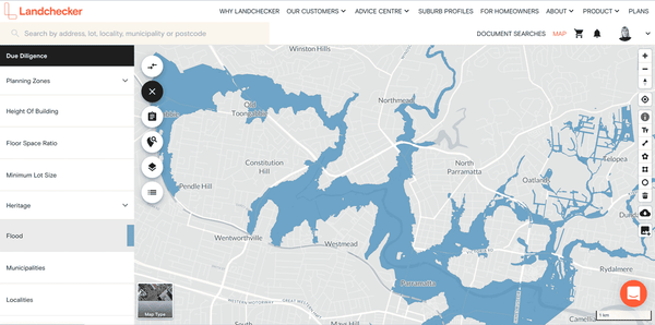
Landchecker customers can visualise the flood data in their map-view by selecting the flood filter in ‘due diligence’. A visual reading of this data is easy even for the untrained eye - for NSW, the state-wide flood layer is displayed as blue without any categorisation, which Landchecker adheres to in its own representation. By turning on the contours, customers see how flood levels are affected by the surrounding terrain and get a feel for how this might shape future flooding events.
To this date we have added flood data to the following areas:
Sutherland
Kogarah
Parramatta
Newcastle
Bellingen
Orange
Shoalhaven
Port Stephens
Greater Taree and Wyong
If you’d like to know more about the new flood mapping in our app, or want to view flood data in an area that isn’t showing any on our map, please reach out to our support team and we will be happy to help you.
As always, we wish all our customers the best, especially those who have been impacted by the floods at this time.
Next Steps:
Sign up for free today to discover more at app.landchecker.com.au/join