Articles
How to Easily and Quickly Check Flood Zones by Address
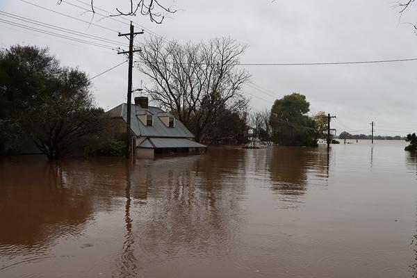
It is estimated that more than one million properties (around 1 in 10 private homes) in Australia are impacted by floods annually.
Whether you are a prospective homeowner, buyer or seller in a flood-prone region or an insurer or property professional seeking accurate, transparent flood risk information – the best way to do so is a digitised check of flood zone data via address.
Updated Australian flood zone data from a trusted source will greatly help in making informed decisions around real and potential flood risk.
What Is a Flood Zone?
Flood zones are areas identified as having elevated flood risk, usually near rivers, creeks, major stormwater drainage systems, lakes and similar bodies of water. Factors considered in determining whether an area is in a flood zone include the elevation of the area, proximity to waterways, flood history and hydrological modelling.
Various methods may be used to categorise flood zones in Australia, which include Annual Exceedance Probability (AEP), Probable Maximum Flood (PMF) and flood storage areas. AEP is usually expressed as a percentage ("%"). AEP of 1% means that the chance of occurrence of a flood of such magnitude or larger in any given year is one in 100.
Meanwhile, PMF refers to the estimated maximum flood size that can occur in an area, representing a rare occurrence. The size of the PMF is usually the extent of the entire floodplain. Finally, flood storage area holds floodwater and then returns it to a river at a controlled rate, after the peak of the flood has passed.
Flood zone mapping exists at both the national and the state levels. The national flood zones offer a wide coverage, whereas the flood zone maps at the state and local levels are detailed.
The Importance of Identifying Flood Zones
To clarify, a flood zone is an area that has a higher potential for flooding. They are most commonly attributed to areas and properties located in a low-lying area or near a river, lake, creek, major stormwater drains, or similar.
As you can imagine, this likelihood varies based on location (suburb and state) as well as the position of the property.
Sign up today to access flood zones
View flood, bushfire and other hazard overlays on your property today.
Why Checking Your Flood Zone Matters
Construction and changes in topography and flood zone designations change overtime, so it’s important that any flood data in Australia that you use is the most up to date.
Below are reasons why one should consider checking whether a property is located within a flood zone.
1. Insurance Premiums
Properties in a flood zone not only have the probability of being damaged by floods, but the owners of such properties will also have to pay a higher insurance premium than those who own properties located outside of flood zones.
2. Property value and resale
Having awareness of whether your property is located in a flood zone is necessary for several reasons. It may affect the property’s market value and its chances of being resold. Check your flood zone to brainstorm effective steps to secure the value of your property.
3. Development Restrictions
If the property is located in a flood area, the conditions may require higher floor levels or specific materials/hydraulic assessments. This naturally may affect renovation costs, extension possibilities, or development potential of the building.
4. Contract Implications for Buyers
The information on flood zones is also very important to the buyers, particularly during the due diligence process. Sellers are expected to provide adequate information during the sale. Buyers need this information to assist them in negotiating the purchase deals with enough finance options.
5. Safety & Risk Mitigation
Even if a property belongs in a lower flood risk zone, such as 1% flood probability annually, it can still be vulnerable to a major flood event. This is why once you have determined your risk level, it is recommended to come up with an appropriate emergency plan and maintenance strategy to take care of your property.
In a report by Climate Council and PropTrack, at least 70% of the 2 million flood-prone houses across the country have seen their value decrease. This highlights the importance of understanding a property’s flood zone to protect the value of your investments.
What the Flood Data Shows — and What It Doesn’t
In Australia, the data used in the flood studies comes from the state government, local government and hydrological models. The factors that combine the data used in flood modelling and simulation include the flood history, topography and rainfall data.
Nevertheless, the level and quality of data access and availability also vary between the states or among the councils within the regions. Some regions have access to current data on flood studies, while others have data derived from previous models and data sets.
However, it’s important to recognise that the degree of flood risk varies due to land use change, developmental schemes, infrastructure schemes, and changes in the climate pattern.
Finally, flood maps show what might happen in terms of flooding in a specific area. However, always remember that flooding will happen depending on certain dynamics, such as the weather. To have a comprehensive view of what could happen, it is good to consult more than one source of information.
Landchecker ingests state and local government flood datasets to provide more targeted, digitised coverage of flood levels across Australia. We have also partnered with ICEYE to provide you with real time satelite imagery of flood events that happened in the country.
Flood Zones in Australia: Key Differences by State
The flood mapping process, as well as the approach to its management, varies in different states in Australia.
New South Wales
NSW has flood mapping supported by the NSW Flood Data Portal, which offers detailed flood maps. Meanwhile, flood studies are managed by each council, which is required by the NSW state government.
In addition, flood planning and flood storage areas are some of the categories used for flood mapping in this state, while development is controlled by the Floodplain Development Manual.
Queensland
QLD uses the Queensland Flood Mapping Program to manage flood data, where local planning schemes contain maps used as overlays. The state recorded major flood events in the last few years, which prompted more investment in improving its mapping and modelling systems.
Victoria
VIC offers flood information through councils and catchment management authorities, while flood overlays are included in the planning schemes.
The state manages flood-prone regions using land subject to inundation overlays and special building overlays.
Western Australia, South Australia and Tasmania
These states have their own system of flood maps, which are mostly coordinated by their respective planning departments and councils.
What to Do if Your Property is in a Flood Zone
If you discover that the property falls within a flood zone, then some measures can be taken:
1. Talk to Insurers
Contacting the insurance companies is necessary for information about the available insurance, as well as possible exclusions of coverage for damages arising out of floods.
2. Request Council Flood Reports
To know the flood risk level in the area, you can freely ask for the reports or the studies of the local authorities concerned.
3. Ask About Historical Flood Events
Another way of getting information is to conduct research on past floods in your region of interest in order to find out the frequency of floods and which regions are prone to flooding.
4. Understand Development Restriction
You may check what limitations exist in developing your project along with your concerned authority if you happen to renovate or extend it.
5. Consider Specialist Building Inspection
Arrange for a technical building inspection with respect to flood resilience, drainage, and any flood-resilience measures already in place.
How Landchecker’s Flood Zone Map & Overlay Can Help
Whilst each state seeks to provide information regarding flood zones to the general public, in many cases and areas, they still lack a consolidated source of information. This in turn means that there are data coverage limitations and inconsistencies in the flood zone data.
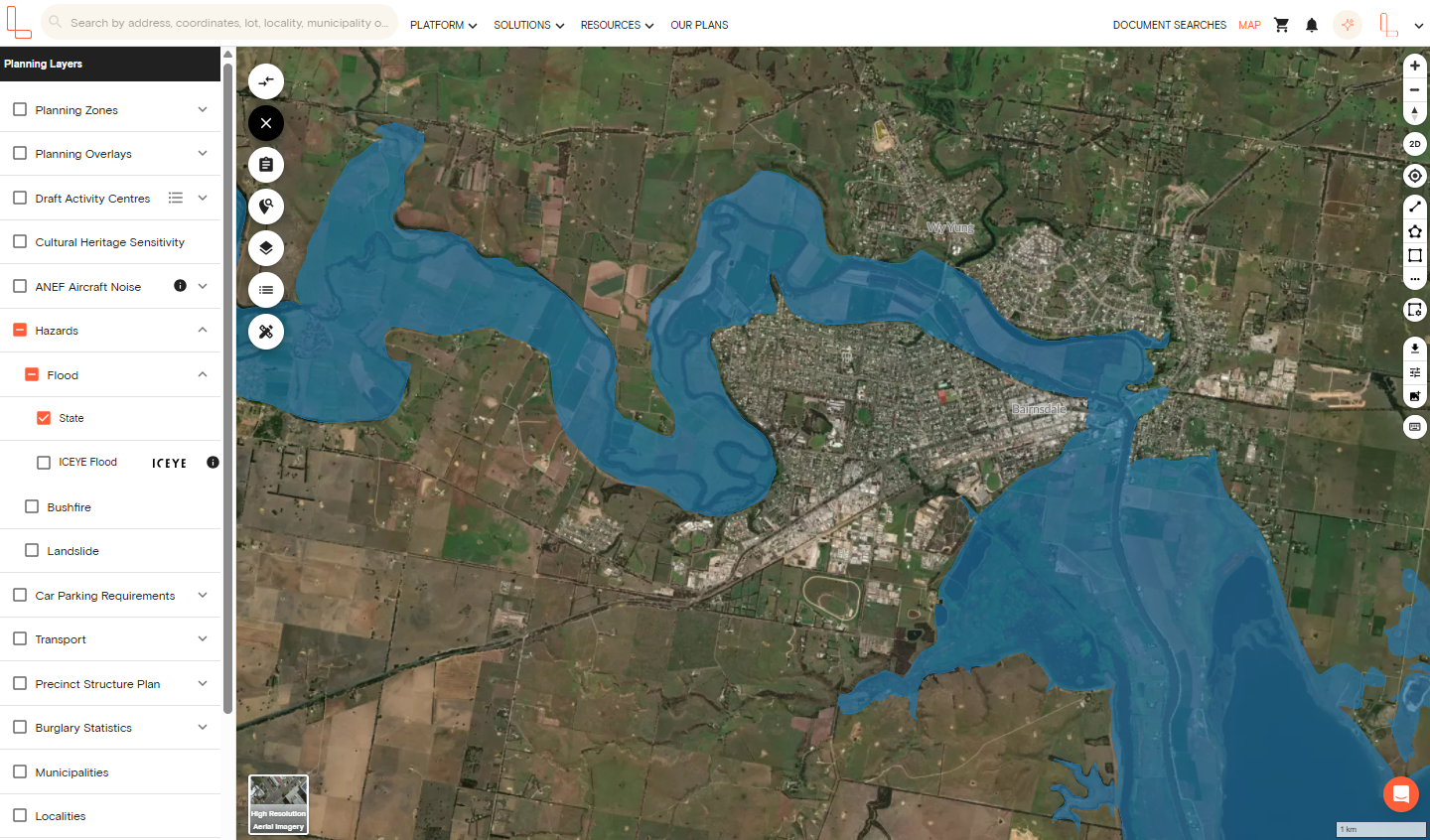
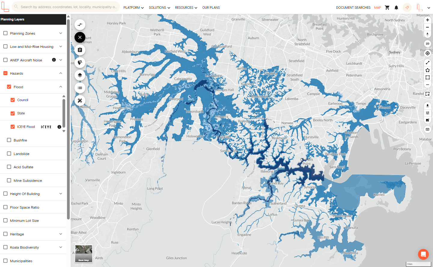
Landchecker helps to overcome these LGA discrepancies by consolidating state and local government dataset providing more targeted, digitised coverage of flood levels and an interactive flood zone map. This enables you to more accurately check flood zone data by address.
Landchecker utilise a range of relevant data (including from Geospatial Specialists) to outline flood behaviour and provide a general overview of the possibility of flooding in a particular area.
A flood zone map includes a range of data, which often includes the following:
Recorded historic floodlines and floodplains
Rainfall and flood gauge records
Stormwater infrastructure
Probable flood flows and volumes
Range of flood levels/depth
Flood hazard overlays and reference layers for planning flood maps
The overlay tool helps guide development and show flood events for the purpose of planning:
It’s helpful to use this Australian flood data for future planning and development, as well as insurance and water safety and quality
Together, the flood zone map and overlay tool can help you be better prepared against flood damage, and provide you with the necessary information to determine if a property is a sound future investment
You can even determine the lowest allowable construction elevation to avoid flood risk
It’s very simple to use and accurately illustrates the risk involved with the specific property address
How to Access Landchecker Flood Zone Map & Overlay Data
Visualise flood data in map-view by selecting Hazards under Planning Layers on the left-hand menu. A visual reading of this data is easy to interpret, even for the untrained eye.
You can turn on the contours or topography to see how flood levels are affected by the surrounding terrain and get a feel for how this may shape future flooding events.
Since some state flood data is incomplete, Landchecker flood data is sourced not only from the state, but also from the local council, to ensure the datasets are more relevant and complete than any competitors only sourcing state data.
To enhance the platform’s historical flood reporting, we also partnered with ICEYE, the world's leader in SAR satellite operations and Earth observation-based natural catastrophe solutions and insights. Watch this webinar to learn how you can use ICEYE’s flood data in your property due diligence.
Next Steps:
Sign up for free today to discover more at app.landchecker.com.au/join
Visit landchecker.com.au for all of the accurate, easy to navigate Australian flood data you need, and the ability to check flood zones via specific property addresses.
Flood Zone FAQs
How do I know if my house is in a flood zone?
The quickest way of doing this is to look into mapping websites, such as Landchecker, which aggregates flood data from state and local government authorities. You can enter your address to ascertain whether flood maps have been applied to the area. Another alternative is approaching your local council to access flood studies and planning certificates.
How accurate are flood zone maps?
Flood maps make use of hydrological modelling and past data, and therefore, the information obtained can be considered only suggestive in nature. Flood maps depend upon the latest flood studies conducted in a particular region. These maps could be more accurate if detailed flood studies were conducted.
How often are flood maps updated?
The frequency of updates varies from one place to another. For instance, in places where there is development, such as in urban areas, it may take 5 to 10 years to update flood studies. Additionally, it is possible that in some places, the flood studies and mapping could have been updated decades ago. New floods and developments may lead to new flood studies.
Does flood risk affect home insurance?
Yes, flood-risk properties have higher premiums and sometimes restricted availability of flood insurance. In some cases, flood insurance is completely excluded on certain properties, requiring higher excesses on such higher-risk flood properties. Flood mitigation can also be useful in reducing premiums.
What's the difference between a 1% AEP and a PMF?
1% Annual Exceedance Probability means that there is a probability of 1% that the event could occur within a given year, and was formerly known as the 1-in-100-year flood event. Probable Maximum Flood refers to the peak flood that is possible and takes into consideration the worst rainfall and soil saturation conditions. Probable Maximum Flood is used if there is critical infrastructure involved.
Are flood zones the same across all states?
No, there is a system for flood mapping in each state, with different terms and data sources used. The most sophisticated systems are in NSW, Victoria, and Queensland, the other states have their systems through local councils.
Can I challenge a flood mapping designation?
Yes, you do have the right to contest the mapping if you think it's wrong. This is normally done by hiring a hydraulic engineer. The councils also reserve the right to reassess the mapping depending on new evidence available.