Articles
All the Ins and Outs of Easement Data and Maps
Imagine you found the perfect property and submitted a development application to build a deck, only to realise there’s a drainage easement occupying the whole width of your property that was not noticed during the settlement process.
Easement data and maps are considered need-to-know information for sellers, investors, or developers. It also offers valuable insights for surveyors, architects, and lawyers seeking specific, enhanced property data. Property professionals use Landchecker to easily visualise easements on a specific property or area with data available nationally.
Editorial note: Landchecker does not provide legal advice. For confirmation and detailed advice about the easement(s) affecting your property, please contact the relevant source authority.
What is an Easement?
An easement grants someone other than the owner legal permission to cross or otherwise use an area of their land. The legal right might be given to a utility authority, neighbour or even the general public.
Easements are legally created and enforced, and typically listed on the property/land title. The rules and regulations vary slightly from state to state within Australia. These are some of the legislative references that manage the registration of easements per state:
Transfer of Land Act 1958 in Victoria
Real Property Act 1900 in New South Wales
Land Title Act 1994 in Queensland
Transfer of Land Act 1893 in Western Australia
Real Property Act 1886 in South Australia
Land Titles Act 1980 in Tasmania
Land Title Act 2000 in the Northern Territory
Land Titles Act 1925 in ACT
Easement data and maps, analysed and visualised, show how a particular easement may affect a current or future owner/seller, buyer, developer (and so on). It provides a greater understanding of the implications easements may have on existing land/property (through both allowances and restrictions).
Types of Easements
There are several forms of easements affecting a property or land in Australia. The most common types of easements are explained below.
| Easement Type | |
|---|---|
| Right of Way/Carriageway | Right of Way/Carriageway Easement refers to the right granted to individuals, corporations, Councils, and other parties by the grantor (owner of the land), allowing the use of a specified area of the grantor’s land for the specific purpose, such as construction of walkways, pathway, driving of vehicles, etc. It is extremely crucial to determine the existence of a Right of Way or Carriageway Easement within one’s own land since this type of easement allows for the retention of ownership rights in the land by the owner, except for the inability of carrying out developments in the same. |
| Service/Utility Easements | Service Utility Easement provides the legal right to enter the property and manage their utilities by the local authorities and any other utility providers, such as electricity and water providers in order to ensure that their services are managed well and for instance laying the cables in a particular section. Service/Utility Easement does not give anyone the right to construct buildings or plantations in this strip. The local authorities may enter this land as needed. For example, Ausgrid requires there should be no construction or plantation close to the electrical cables, transformers, poles, equipment, or supporting wires within five meters of the steel electric poles |
| Support Easement or Party Wall | The party wall is common among multi-level structures or those where there are walls built between several pieces of land. With this type of easement, both landowners have the assurance of using the wall as a support wall. With this type of easement, the neighbours gain rights to permanently use the property. This makes the alteration of this piece of shared property illegal without consideration of this easement. |
| Light and Air Easements | Easements on light and air control any structures that will interfere with light and air supply, especially significant in high-density regions. The construction of structures by neighbours that will limit your access to light or air is typically illegal. The reason why easement on light and air is essential in high-density regions is that loss of natural light decreases land value. |
| Easement in Gross | Easement in gross allows the individual or organisation to use the property of others, normally for gaining access and services. For instance, an electrical company gets an easement in gross so that it can construct or maintain its facilities on the land of another person. The present easement in gross would cease to exist if the easement holder sold off the property, contrary to easements appurtenant that follow the transfer of the land title. |
| Easement by Necessity | An easement by necessity gives someone or an organisation the right to utilise another's land to maximise their benefit from their own property. It is caused by a portion of land being subdivided from the rest, with the subdivision then sold off or kept separately. In other words, there is a need for an individual to use another individual's land to gain access to the highway. |
How Easements are Registered and Searched: Victoria, New South Wales and Queensland
The legal framework for easements is fairly consistent across the state. However, the terms, registration systems, and creation or removal processes differ slightly. VIC, NSW and QLD are the three most commonly searched states on Landchecker. Here’s a quick comparison for each state:
| VIC | NSW | QLD | |
|---|---|---|---|
| Governing Legislation | Transfer of Land Act 1958 | Real Property Act 1900 | Land Title Act 1994 |
| Land Titles Authority | Land Use Victoria (DELWP) | NSW Land Registry Services | Titles Queensland (DNRME) |
| Easement Registration | Registered on Certificate of Title; the instrument document holds the full terms | Registered on Certificate of Title; 88B instrument attached to the deposited plan | Registered on Title Search (Register Search Statement); the instrument document holds the full terms |
| Primary Search Method | Title search + copy of plan via Landchecker | Title search + 88B instrument Landchecker | Title search + copy of plan via Landchecker |
| Easements Shown in Landchecker | Yes — colour-coded by type on the Advanced and Enterprise plans | Yes — on map; 88B instrument available via document search | Yes — on map; copy of plan available via document search |
Victoria
The creation and removal of easements in Victoria follows different legislation, such as the Subdivision Act 1988 (Vic), the Transfer of Land Act 1958 (Vic), the Victoria Planning Provisions (Clause 52.02), and Land Use Victoria requirements.
Clause 52.02 of the Victoria Planning Provisions requires a planning permit when creating, varying or removing an easement on a property before creating a new plan or altering the easement.
Subdivision Act 1988 sets out the procedure for the variation or removal of easements. It also regulates the management of and dealings with common properties.
New South Wales
Under the Real Property Act 1900, the creation of easements over Torrens Title land includes those from express grants of easement in the instrument of transfer, mortgage, lease or charge.
Queensland
The Land Title Act 1994 governs the registration of easements under Titles Queensland and is listed in the register search statement with a corresponding dealing number for each registered interest.
Sign up today to verify easements in seconds
Easement data is available nationally on Landchecker
How Easements Affect Property Decisions
Easements may restrict what you can build or renovate with a certain part of your property, affecting property decisions for homeowners, buyers and sellers. Here are some cases on how easements impact property use. It could also modify how you use your property even before you intend to proceed with formal developments.
For property developers, easements have an effect on yield, design, and feasibility. An easement on services running across the middle of a development site may require that all plans revolve around it.
For example, a homeowner in NSW planned to knock down a property and build a duplex development on the site. But before advancing with the project, they needed to know more about the stormwater easement attached to the property.
So what they did was purchase a copy of plan to know the position and orientation of the easement together with its relation to the drainage pipe. The position, size, and orientation of the easement would help them finalise which part of their land would be used to construct the duplex. The copy of plan showed there was a stormwater drainage easement along the boundary of the property in NSW that takes into consideration the natural gradient which is directed from the street towards the rear drain.
By identifying the exact location and width of the easement, the owner was able to determine the actual amount of buildable land available, and found out that buying 3-5 sqm of land from the rear neighbour would provide the needed 700 sqm for dual occupancy.
If they failed to identify the existence of an easement on the property, they were buying land that would be included in the prohibited strip and would still be unable to meet the threshold for dual-occupancy development. In addition, the submitted plans might be rejected due to the lack of identification of the easement on the site.
Common Mistakes People Make with Easements
Easements are among the most misunderstood aspects of property ownership in Australia. Easements are commonly attached to the property rather than a specific owner, and new owners may overlook that easements run with the land resulting in costly expenses.
Here are some of the common mistakes people and property professionals make with easements.
1. Not Checking the Title
Other than the physical inspection of the property itself, it is vital to obtain a copy of the certificate of title, the plan, and other documentation to determine what easements have been established on the property and how they have been marked. Stormwater drainage systems, sewage systems, and other utilities are not visible but tangible. Your conveyancer or solicitor can then review what’s listed on the documents and indicate anything that needs a closer inspection.
2. Unregistered or Missing Easements
Another common mistake is assuming that a property does not have an easement attached to it when the property simply has unregistered or missing easements. This can be caused by different reasons, such as historical rights, statutory exceptions, or long-standing utility exemptions under the Torrens title system.
These types of easements are hard to identify through standard searches. This is why it’s important to inspect the property for informal tracks or worn access paths. If you found something that looks ambiguous, you can also contact a surveyor.
How to Check Easements on a Property Using Landchecker
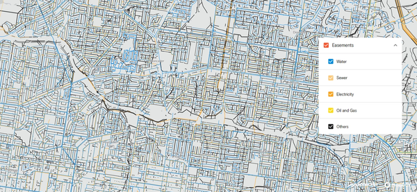
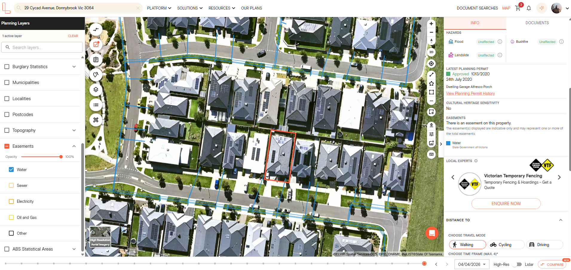
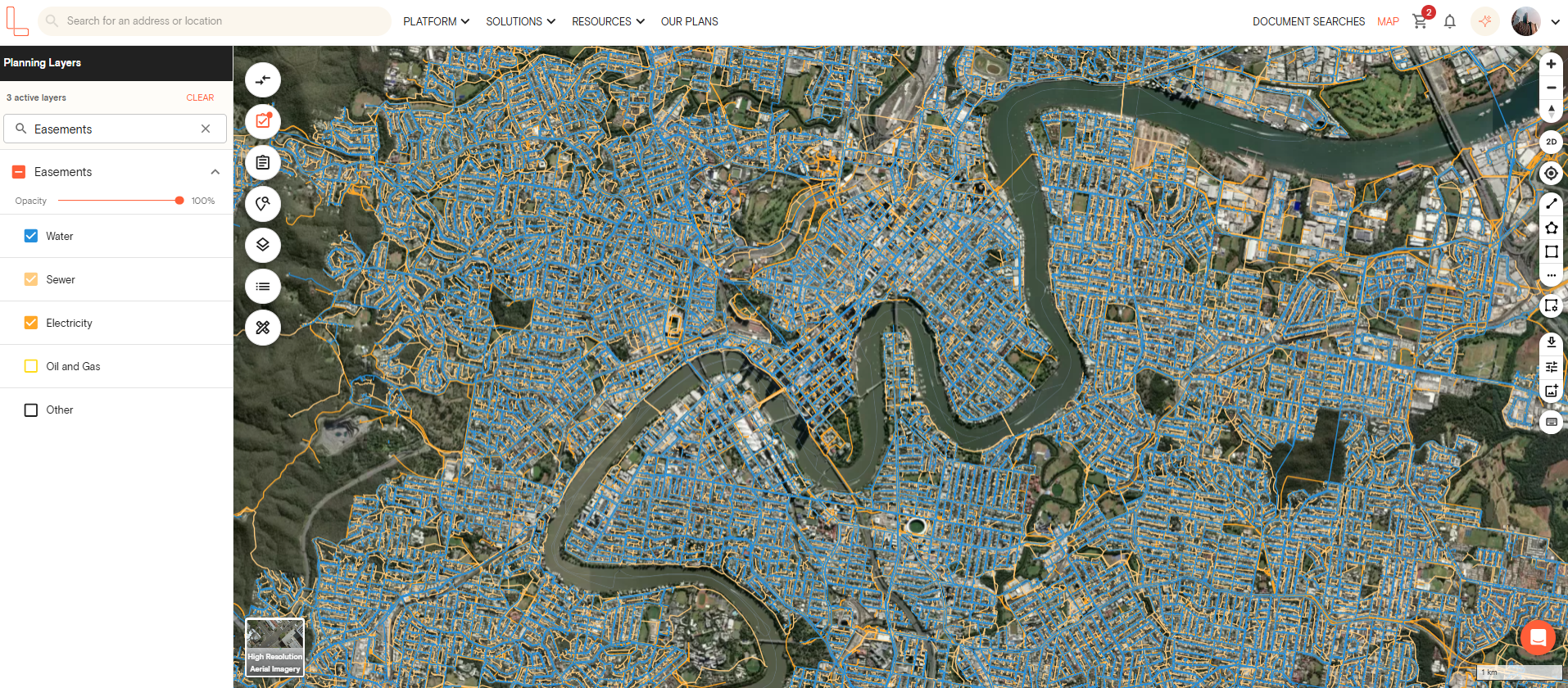
Landchecker offers a range of easement data across properties within Australia. Data is displayed in an easy-to-interpret combination of analytics, layered maps, boundaries and more.
Collectively, you can apply relevant filters to the data for even greater insights for your specific property context and individualised needs.
Accessing Landchecker easement information using the easement map filter is simple, all you need to do is:
1. Search for a property or land parcel using the address search bar
2. Open the Planning Layers menu on the left-hand side
3. Use the search bar to find the easements layer or scroll down to tick the checkbox for easements
4. Easement lines will be displayed on the map for the selected property
If you are on an Advanced plan, the easements are colour-coded by type for easier identification.
Detailed easement information is available via a Landchecker Premium Property Report or purchase a copy of plan as a final check to see all easements associated with the property. If your property has an easement, you can also purchase a certificate of title, where you can find the dealing or instrument number to obtain the full details of the easement.
We recommend making your search even more robust and exhaustive by also consulting a professional or your local council for the most complete picture possible of all registered easements.
In addition to easement data, a Premium Property Report will also provide other essential up-to-date insights for a particular property, such as valuations, heritage layers, planning zones and permits and much more.
What Digital Easement Data Does and Doesn't Cover
Digital easement data often shows registered easements on a certificate of title, including easements in gross, utility easements and right of way. Most proptech platforms display these digital easement data as lines overlaid on lot boundaries. This way homeowners or property professionals can see the approximate geographic location and extent of the easement online.
Meanwhile, unregistered easements, easements implied by law and prescriptive easements typically do not appear in digital easement datasets. Digital easement data also does not cover pending or in-progress easements until the lodgement process is completed.
Finally, an easement’s depth and layering conditions are rarely captured in digital easement datasets. You may need to purchase the actual dealing or instrument document to learn more details about the easement in your property.
Frequently Asked Questions
What is an easement on a property in Australia?
Easements are legal rights given to individuals, authorities or companies to use part of a property or land for a specific purpose, such as walkways, pathways, party walls, right to park a vehicle, drainage or services.
How do I find out if a property has an easement?
There are many ways you can confirm if your property has an easement. You may use Landchecker to find out if your property has an easement. You can also purchase a copy of plan and certificate of title as a source of truth for confirming easements.
Can I build over an easement?
Yes, there is a possibility that you can build over an easement. However, there may be specific guidelines and restrictions you need to follow. Depending on the easement terms and jurisdiction, you may need written permission from the local council and relevant service authorities confirming you can build something on the property
Do easements show up on a title search?
Depending on the state, easements may show up on a title search. If there is a registered easement on your property, you need to look for the dealing or instrument number on the certificate of title. Then you can use the dealing number to purchase the document containing more information about the easement.
What's the difference between an easement and a covenant?
An easement is a legal right to use someone else’s land for a specific purpose, while a covenant is a legal agreement restricting the use of a piece of property.
How accurate is the easement data on Landchecker?
The easement data within Landchecker is collated from multiple sources across each state and territory. The easements data on Landchecker represent digitised easements only and may only reflect a subset of total easements on a property. The certificate of title and a copy of plan remain the source of truth for confirming easements.
Next Steps:
Sign up for free today to discover more at app.landchecker.com.au/join