Wanneroo WA 6065
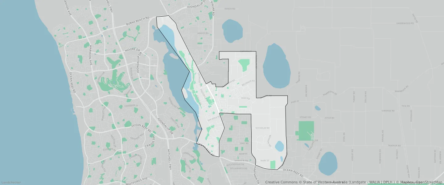
This Wanneroo suburb profile includes demographic data and planning information to help you make an informed property decision.
An average home in Wanneroo is owned with a mortgage by couples with children. The average age in Wanneroo is 41. Separate houses are common in Wanneroo and the area is mostly URBAN DEFERRED ZONE (33.77%), URBAN ZONE (28.12%) and URBAN (28.12%).
Wanneroo demographics
Population
12113
Average Age
41
Age Distribution
Employment Type
Median Weekly Income
Traveled to Work
Car
84.1%
Tram
0.0%
Bicycle
0.1%
Train
1.9%
Walking
1.9%
Bus
2.0%
Wanneroo property information
Number of Bedrooms
Tenure Type
Property Types in Wanneroo
Separate house
Semi detached house
Unit/Apartment
Median monthly mortgage repayments
$1,736
Median weekly rental payments
$350
Average number of bedrooms per dwelling
3.5
Average number of people per household
3
Household Composition
Family Composition
Couple family without children
One parent family
Couple family with children
WANNEROO planning zones
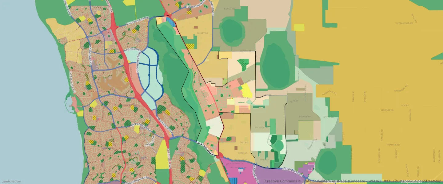
| Zone Code | Zone Name | Percentage Covered | Area Covered | |
|---|---|---|---|---|
| CENTRE | CENTRE | 2.12% | 424,281.42㎡ | |
| CIVIC AND COMMUNITY | CIVIC AND COMMUNITY | 0.01% | 1,986.25㎡ | |
| COMMERCIAL | COMMERCIAL | 0.02% | 3,006.95㎡ | |
| DRAINAGE AND WATERWAYS | DRAINAGE AND WATERWAYS | 0.09% | 17,421.56㎡ | |
| EDUCATION | EDUCATION | 0.23% | 45,543.29㎡ | |
| ENVIRONMENTAL CONSERVATION RESERVE | ENVIRONMENTAL CONSERVATION RESERVE | 0.04% | 8,399.68㎡ | |
| LIGHT INDUSTRY | LIGHT INDUSTRY | 0.2% | 39,170.29㎡ | |
| LOCAL ROAD | LOCAL ROAD | 10.66% | 2,129,012.66㎡ | |
| OTHER REGIONAL ROADS | OTHER REGIONAL ROADS RESERVE | 0.56% | 111,225.02㎡ | |
| PRIMARY REGIONAL ROADS | PRIMARY REGIONAL ROADS RESERVE | 1.18% | 236,533.79㎡ | |
| PUBLIC OPEN SPACE | PUBLIC OPEN SPACE | 2.32% | 463,298.1㎡ | |
| PUBLIC PURPOSES | PUBLIC PURPOSES | 0.08% | 15,644.73㎡ | |
| PUBLIC PURPOSES | PUBLIC PURPOSES RESERVE | 0.08% | 15,644.73㎡ | |
| PUBLIC PURPOSES - HIGH SCHOOL | PUBLIC PURPOSES - HIGH SCHOOL RESERVE | 0.64% | 128,812.78㎡ | |
| PUBLIC PURPOSES - PUBLIC UTILITIES | PUBLIC PURPOSES - PUBLIC UTILITIES | 1.58% | 315,720.8㎡ | |
| PUBLIC PURPOSES - PUBLIC UTILITIES | PUBLIC PURPOSES - PUBLIC UTILITIES RESERVE | 1.58% | 315,720.8㎡ | |
| R15 | R15 | 0.78% | 155,627.14㎡ | |
| R2 | R2 | 3.53% | 704,490.47㎡ | |
| R20 | R20 | 10.12% | 2,020,497.12㎡ | |
| R20/40 | R20/40 | 5.72% | 1,142,840.51㎡ | |
| R20/60 | R20/60 | 0.61% | 122,593.57㎡ | |
| R2.5 | R2.5 | 0.03% | 6,565.99㎡ | |
| R30 | R30 | 0.19% | 37,399.5㎡ | |
| R40 | R40 | 0.39% | 77,108.16㎡ | |
| R5 | R5 | 0.38% | 76,888.19㎡ | |
| R60 | R60 | 0.08% | 15,340.19㎡ | |
| REGIONAL OPEN SPACE | REGIONAL OPEN SPACE | 23.23% | 4,640,808.3㎡ | |
| REGIONAL OPEN SPACE | REGIONAL OPEN SPACE RESERVE | 23.23% | 4,640,808.3㎡ | |
| RESIDENTIAL | RESIDENTIAL | 18.46% | 3,688,115.6㎡ | |
| RURAL | RURAL | 10.9% | 2,177,465㎡ | |
| RURAL | RURAL | 23.43% | 4,678,699.27㎡ | |
| RURAL | RURAL ZONE | 10.9% | 2,177,465㎡ | |
| RURAL | RURAL ZONE | 23.43% | 4,678,699.27㎡ | |
| RURAL RESIDENTIAL | RURAL RESIDENTIAL | 14.36% | 2,868,268.64㎡ | |
| SERVICE COMMERCIAL | SERVICE COMMERCIAL | 0.61% | 122,027.69㎡ | |
| SPECIAL USE | SPECIAL USE | 0.17% | 33,416.61㎡ | |
| URBAN | URBAN | 28.12% | 5,618,009.89㎡ | |
| URBAN | URBAN ZONE | 28.12% | 5,618,009.89㎡ | |
| URBAN DEFERRED | URBAN DEFERRED ZONE | 33.77% | 6,745,852.39㎡ | |
| URBAN DEVELOPMENT | URBAN DEVELOPMENT | 1.45% | 289,771.75㎡ |
Looking to research a property in WANNEROO?
Go to mapData Source - ABS