Kingsley WA 6026
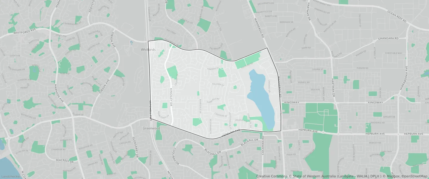
This Kingsley suburb profile includes demographic data and planning information to help you make an informed property decision.
An average home in Kingsley is owned with a mortgage by couples with children. The average age in Kingsley is 44. Separate houses are common in Kingsley and the area is mostly URBAN ZONE (70.19%), URBAN (70.19%) and RESIDENTIAL (46.79%).
Kingsley demographics
Population
13204
Average Age
44
Age Distribution
Employment Type
Median Weekly Income
Traveled to Work
Car
83.7%
Tram
0.0%
Bicycle
0.4%
Train
6.2%
Walking
1.1%
Bus
0.9%
Kingsley property information
Number of Bedrooms
Tenure Type
Property Types in Kingsley
Separate house
Semi detached house
Unit/Apartment
Median monthly mortgage repayments
$2,000
Median weekly rental payments
$418
Average number of bedrooms per dwelling
3.7
Average number of people per household
3
Household Composition
Family Composition
Couple family without children
One parent family
Couple family with children
KINGSLEY planning zones
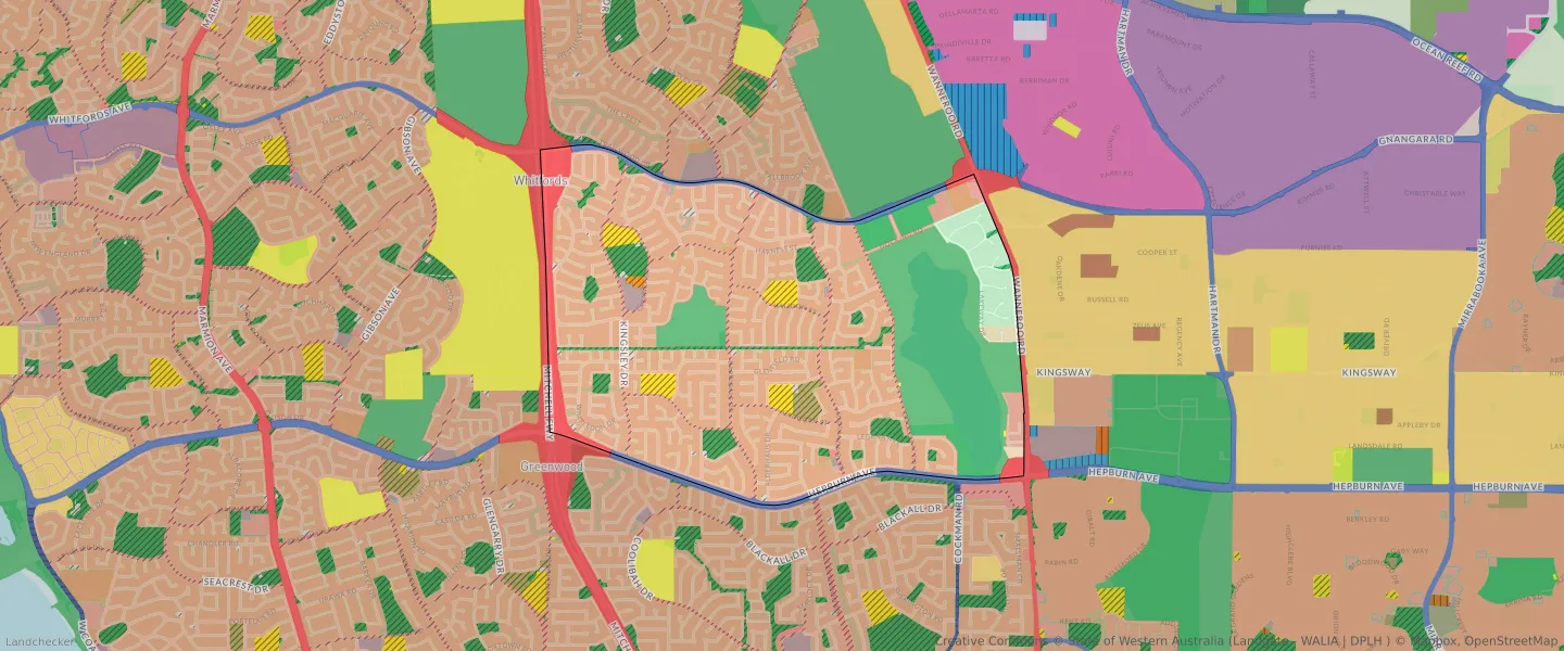
| Zone Code | Zone Name | Percentage Covered | Area Covered | |
|---|---|---|---|---|
| CIVIC AND COMMUNITY | CIVIC AND COMMUNITY | 0.13% | 10,012.1㎡ | |
| COMMERCIAL | COMMERCIAL | 0.42% | 31,599.75㎡ | |
| DRAINAGE AND WATERWAYS | DRAINAGE AND WATERWAYS | 0.37% | 27,795.8㎡ | |
| ENVIRONMENTAL CONSERVATION RESERVE | ENVIRONMENTAL CONSERVATION RESERVE | 0.65% | 49,122.72㎡ | |
| LOCAL DISTRIBUTOR ROAD | LOCAL DISTRIBUTOR ROAD | 3.8% | 288,060.32㎡ | |
| LOCAL ROAD | LOCAL ROAD | 14.73% | 1,117,419.33㎡ | |
| MIXED USE | MIXED USE | 0.09% | 6,959.79㎡ | |
| OTHER REGIONAL ROADS | OTHER REGIONAL ROADS RESERVE | 2.19% | 166,354.6㎡ | |
| PRIMARY REGIONAL ROADS | PRIMARY REGIONAL ROADS RESERVE | 3.47% | 263,638.5㎡ | |
| PRIVATE COMMUNITY PURPOSES | PRIVATE COMMUNITY PURPOSES | 0.84% | 63,569.14㎡ | |
| PUBLIC OPEN SPACE | PUBLIC OPEN SPACE | 4.27% | 324,028.65㎡ | |
| PUBLIC PURPOSES | PUBLIC PURPOSES | 1.98% | 150,574.7㎡ | |
| PUBLIC PURPOSES | PUBLIC PURPOSES RESERVE | 1.98% | 150,574.7㎡ | |
| PUBLIC PURPOSES - PUBLIC UTILITIES | PUBLIC PURPOSES - PUBLIC UTILITIES | 0.02% | 1,226.41㎡ | |
| PUBLIC PURPOSES - PUBLIC UTILITIES | PUBLIC PURPOSES - PUBLIC UTILITIES RESERVE | 0.02% | 1,226.41㎡ | |
| R20 | R20 | 33.91% | 2,572,845㎡ | |
| R20/40 | R20/40 | 7.76% | 588,857.32㎡ | |
| R20/60 | R20/60 | 0.99% | 75,002.15㎡ | |
| R40 | R40 | 0.64% | 48,505.01㎡ | |
| R5 | R5 | 3.49% | 264,611.57㎡ | |
| REGIONAL OPEN SPACE | REGIONAL OPEN SPACE | 19.95% | 1,513,430.8㎡ | |
| REGIONAL OPEN SPACE | REGIONAL OPEN SPACE RESERVE | 19.95% | 1,513,430.8㎡ | |
| RESIDENTIAL | RESIDENTIAL | 46.79% | 3,549,864.51㎡ | |
| RURAL | RURAL | 3.65% | 276,969.11㎡ | |
| RURAL | RURAL ZONE | 3.65% | 276,969.11㎡ | |
| SERVICE COMMERCIAL | SERVICE COMMERCIAL | 0.32% | 24,320.39㎡ | |
| URBAN | URBAN | 70.19% | 5,324,731.37㎡ | |
| URBAN | URBAN ZONE | 70.19% | 5,324,731.37㎡ | |
| URBAN DEFERRED | URBAN DEFERRED ZONE | 0.53% | 40,364.35㎡ |
Looking to research a property in KINGSLEY?
Go to mapData Source - ABS