Greenfields WA 6210
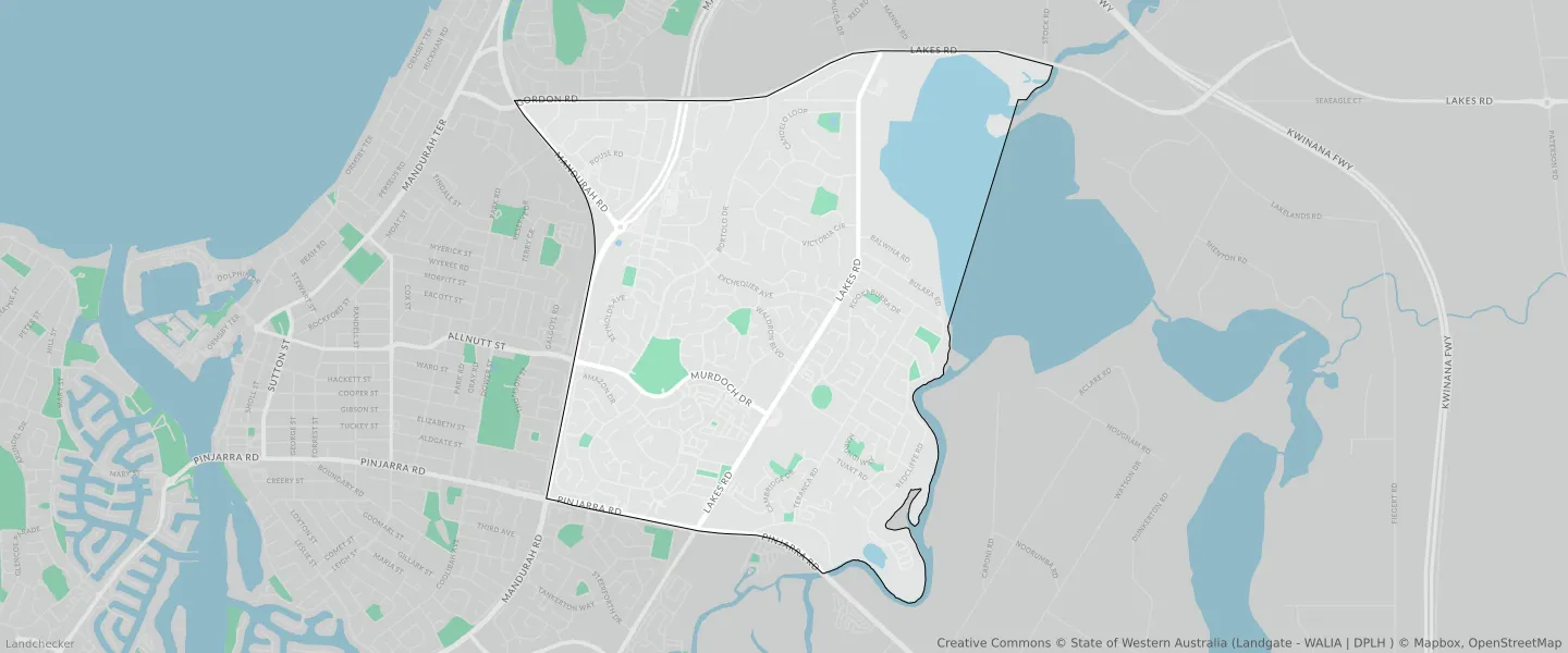
This Greenfields suburb profile includes demographic data and planning information to help you make an informed property decision.
An average home in Greenfields is owned with a mortgage by couples without children. The average age in Greenfields is 47. Separate houses are common in Greenfields and the area is mostly URBAN ZONE (63.2%), URBAN (63.2%) and RESIDENTIAL (37.35%).
Greenfields demographics
Population
9869
Average Age
47
Age Distribution
Employment Type
Median Weekly Income
Traveled to Work
Car
82.0%
Tram
0.0%
Bicycle
0.4%
Train
2.1%
Walking
2.0%
Bus
2.8%
Greenfields property information
Number of Bedrooms
Tenure Type
Property Types in Greenfields
Separate house
Semi detached house
Unit/Apartment
Median monthly mortgage repayments
$1,387
Median weekly rental payments
$295
Average number of bedrooms per dwelling
3.3
Average number of people per household
2
Household Composition
Family Composition
Couple family without children
One parent family
Couple family with children
GREENFIELDS planning zones
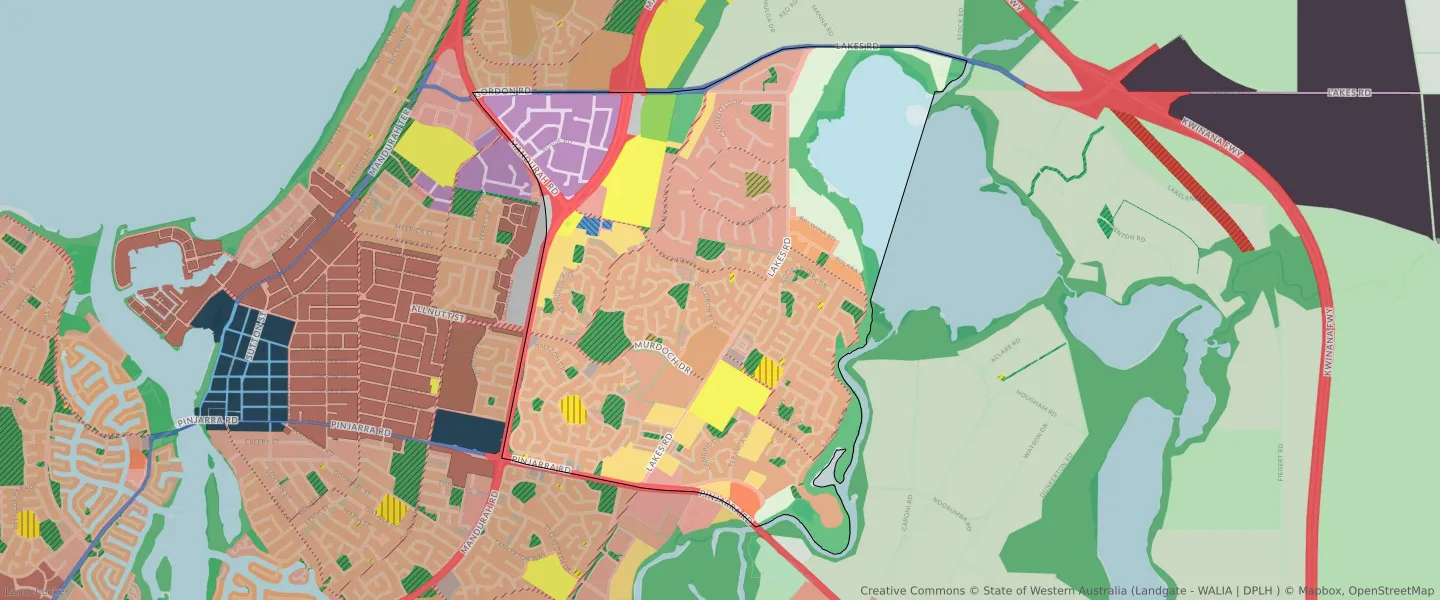
| Zone Code | Zone Name | Percentage Covered | Area Covered | |
|---|---|---|---|---|
| EDUCATION | EDUCATION | 0.77% | 77,133.45㎡ | |
| ENVIRONMENTAL CONSERVATION RESERVE | ENVIRONMENTAL CONSERVATION RESERVE | 0.41% | 41,110.3㎡ | |
| GENERAL INDUSTRY | GENERAL INDUSTRY | 4.68% | 467,682.37㎡ | |
| INDUSTRIAL | INDUSTRIAL | 5.68% | 566,927.71㎡ | |
| INDUSTRIAL | INDUSTRIAL ZONE | 5.68% | 566,927.71㎡ | |
| LOCAL CENTRE | LOCAL CENTRE | 0.38% | 37,664.65㎡ | |
| LOCAL DISTRIBUTOR ROAD | LOCAL DISTRIBUTOR ROAD | 2.45% | 244,641.68㎡ | |
| LOCAL ROAD | LOCAL ROAD | 11.47% | 1,145,581.1㎡ | |
| NEIGHBOURHOOD CENTRE | NEIGHBOURHOOD CENTRE | 0.24% | 24,303.31㎡ | |
| OTHER REGIONAL ROADS | OTHER REGIONAL ROADS RESERVE | 0.71% | 71,295.13㎡ | |
| PRIMARY REGIONAL ROADS | PRIMARY REGIONAL ROADS RESERVE | 3.15% | 314,856.87㎡ | |
| PRIVATE COMMUNITY PURPOSES | PRIVATE COMMUNITY PURPOSES | 1.89% | 188,622.13㎡ | |
| PRIVATE RECREATION | PRIVATE RECREATION | 0.89% | 88,853.66㎡ | |
| PRIVATE RECREATION | PRIVATE RECREATION ZONE | 0.89% | 88,853.66㎡ | |
| PUBLIC OPEN SPACE | PUBLIC OPEN SPACE | 4.17% | 416,094.68㎡ | |
| PUBLIC PURPOSES | PUBLIC PURPOSES | 0.12% | 11,757.86㎡ | |
| PUBLIC PURPOSES | PUBLIC PURPOSES RESERVE | 0.12% | 11,757.86㎡ | |
| PUBLIC PURPOSES - HOSPITAL | PUBLIC PURPOSES - HOSPITAL RESERVE | 2.03% | 202,501.05㎡ | |
| PUBLIC PURPOSES - PUBLIC UTILITIES | PUBLIC PURPOSES - PUBLIC UTILITIES | 0.24% | 23,681.18㎡ | |
| PUBLIC PURPOSES - PUBLIC UTILITIES | PUBLIC PURPOSES - PUBLIC UTILITIES RESERVE | 0.24% | 23,681.18㎡ | |
| PUBLIC PURPOSES - UNIVERSITY | PUBLIC PURPOSES - UNIVERSITY RESERVE | 2.71% | 270,224.89㎡ | |
| R10 | R10 | 0.58% | 58,001.56㎡ | |
| R20 | R20 | 23.79% | 2,375,215.59㎡ | |
| R30 | R30 | 1.36% | 135,635.4㎡ | |
| R40 | R40 | 1.27% | 126,749.24㎡ | |
| R5 | R5 | 10.75% | 1,073,254.46㎡ | |
| R-AC3 | R-AC3 | 0.24% | 24,303.31㎡ | |
| RAILWAYS | RAILWAYS RESERVE | 0.44% | 44,224.12㎡ | |
| REGIONAL OPEN SPACE | REGIONAL OPEN SPACE | 7.64% | 763,034.16㎡ | |
| REGIONAL OPEN SPACE | REGIONAL OPEN SPACE RESERVE | 7.64% | 763,034.16㎡ | |
| RESIDENTIAL | RESIDENTIAL | 37.35% | 3,729,109.76㎡ | |
| RURAL | RURAL | 4.28% | 427,378.58㎡ | |
| RURAL | RURAL ZONE | 4.28% | 427,378.58㎡ | |
| RURAL RESIDENTIAL | RURAL RESIDENTIAL | 4.17% | 416,563.6㎡ | |
| SERVICE COMMERCIAL | SERVICE COMMERCIAL | 0.63% | 63,136.68㎡ | |
| TOURISM | TOURISM | 0.43% | 42,954.08㎡ | |
| URBAN | URBAN | 63.2% | 6,310,065.58㎡ | |
| URBAN | URBAN ZONE | 63.2% | 6,310,065.58㎡ | |
| URBAN DEVELOPMENT | URBAN DEVELOPMENT | 4.87% | 486,529.36㎡ | |
| WATERWAYS | WATERWAYS | 9.03% | 902,260.92㎡ | |
| WATERWAYS | WATERWAYS RESERVE | 9.03% | 902,260.92㎡ |
Looking to research a property in GREENFIELDS?
Go to mapData Source - ABS