
Product Help
How to view easements on a property
An easement is a legal right that allows someone else to use part of a property for a specific purpose, such as access, drainage or utility services.
Easements can affect how you or your clients use or develop a property, so it’s important to check them early in your due diligence process. With Landchecker, you can view registered easements online.
Follow the steps below to display the easements layer on the Landchecker map.
Viewing Easements via Planning Layers
1. Search for a property or land parcel using the address search bar.
2. In the left-hand panel, open the Planning Layers menu, scroll down and tick the checkbox for Easements.
3. When you enable the easements layer, easement lines will be displayed on the map for the selected property.
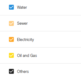
If you are on an Advanced plan, the easements are colour-coded by type for easier identification.
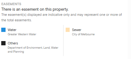
Under the Planning Information section on the right-hand information panel, you'll also see a list of the specific types of easements found on the property.
If you're on a Standard plan, easements will be displayed in red on the map, and the easements section on the right-hand side information panel will be locked.
Upgrade today to access detailed Easements
Already on Advanced? Log in to view easements on your property.
Download a Property Report
If you need a physical or digital copy of the easements for due diligence, you can view and download a property report.
Simply click the View Report button on the right-hand side information panel.
In the report customisation options, you can select which data layers to include.
To create a focused report, simply untick all other data and choose to display only the easements.
If you’re on an Advanced plan, you can create a branded premium report cover that includes your company logo and a customised cover.
Purchase a Document
The easement(s) displayed on the Landchecker map are indicative and may represent one or more of the total easements.
Once you have the dealing or instrument number from the title, you can use it to purchase the specific document containing further details about the easement through the document searches page and select standard searches.
Related articles
How to check a property's planning zone
A quick overview of Site Finder
How to view and filter planning permit information - an overview
How to create a project and save a property (through your profile)