Articles
NSW Flood Zones
New South Wales has some of the most complex flood risk exposure in Australia. River flooding affects inland valleys and floodplains, while estuary flooding affects low-lying areas along the coast. Flash flooding can also affect urban areas within minutes following a heavy rainfall event.
Flood mapping in NSW is managed at the council level, which means that data can vary from one council to another. Using the Landchecker is one of the fastest ways to check flood risk by address, as we’ve brought together the flood mapping data available from both state and local government levels in one easy-to-use platform.
Read on to learn more about flood zones in NSW, how to check NSW flood zones using Landchecker, and the insurance and property implications of flooding in the state.
What Are Flood Zones in NSW?
A flood-prone land refers to areas susceptible to flooding as classified by the Probable Maximum Flood (PMF). PMF is the estimated maximum flood that could possibly occur in a specific catchment, which can be considered a rare and unlikely event.
Within a flood-prone area, flood risk is also divided into the likelihood of its occurrence. The 1% Annual Exceedance Probability (AEP) is the most commonly used method to categorise floods. AEP is the probability of occurrence of a flood of a given size or larger in a given year. This is expressed as a percentage. For example, an AEP flood event of 1% has a 1% chance of occurring in a given year.
In addition, there is flood storage land and floodways. Flood storage land is land that holds and slows the flood. Floodways are areas of concentrated flow where development is a serious risk to life and property.
The flood risk in New South Wales is managed by a system that includes the NSW State Emergency Service (SES), which is responsible for the coordination of emergency responses to floods. The local councils are also given the responsibility of commissioning and managing flood studies and the Floodplain Risk Management Plans. Finally, the NSW Department of Planning provides the planning policy framework in NSW under the Flood Prone Land Policy.
When a property professional asks, "Is this property susceptible to flooding in NSW?", the response would normally begin with information from the local council.
How Flood Mapping Works in NSW
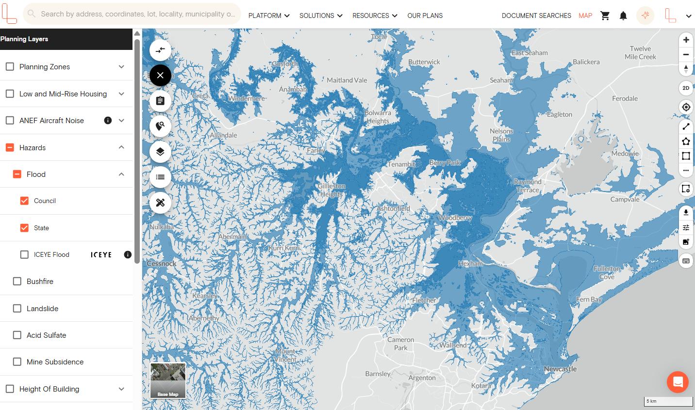
In NSW, flood mapping is managed by local councils. Each Local Government Area (LGA) conducts its own flood study, based on different factors including rainfall, land elevation, drainage systems, and flood history, to identify where floodwater flows in the area. This data is used to create Floodplain Risk Management Plans.
Since each council has their own flood mapping process, the level of accuracy for flood mapping data can vary in NSW. You will see distinctions between:
Flood-prone land – all land within the PMF boundary
Overland flow – localised flooding from stormwater that is not from a waterway; common in high-density urban areas
Flood storage – low-lying areas that temporarily store floodwater; often with very strict development controls
Flood planning levels – the lowest floor level permitted for new development in a flood-prone area
Being able to identify which one is relevant to a specific property can make a world of difference in how that property can be used, developed, or insured.
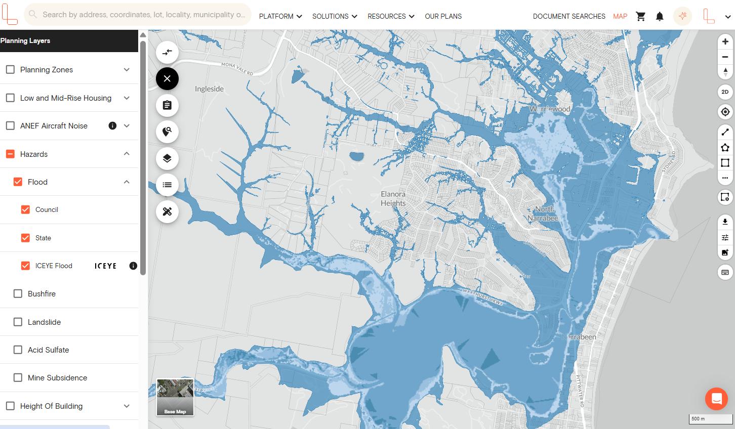
How to Check NSW Flood Zones Using Landchecker
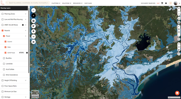
The flood data layer on the Lanchecker platform is available for our Standard, Advanced, and Enterprise plan members.
1. Open the Landchecker map and search for your specific property or zoom in on your area of interest.
2. Click the Planning Layers menu on the left-hand side menu and select Hazards.
3. Select Flood, and a dropdown option appears where you can select council, state or ICEYE flood where data is available.
Note: Go to our Coverage Map page to check current flood data availability per council. This page will be updated as we release more flood data from more councils into the Landchecker platform.
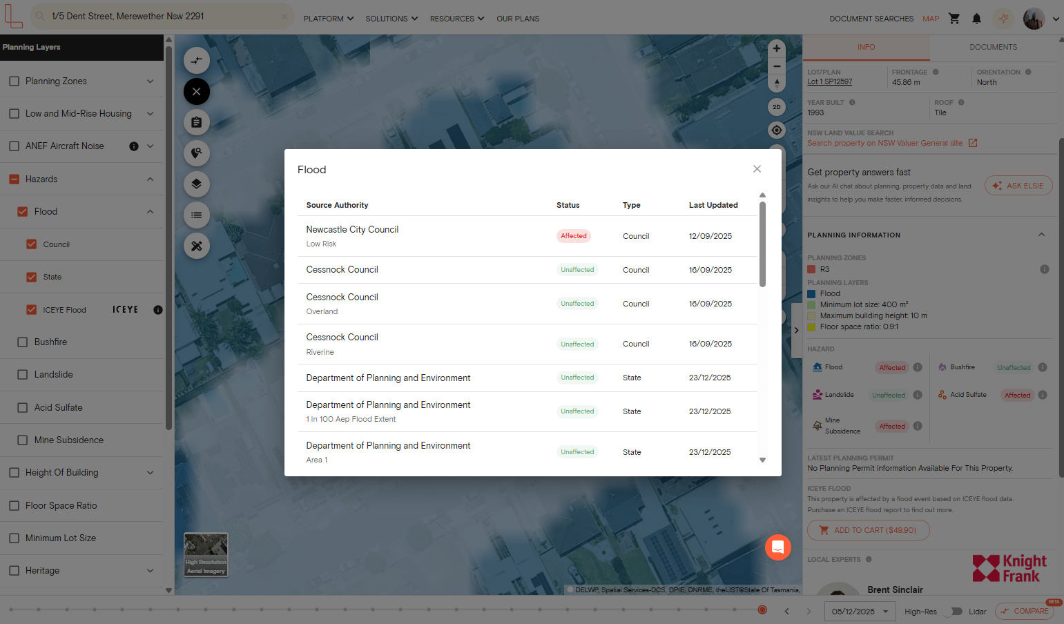
4. On the right-hand side panel, scroll down to the Planning Information section and click the Hazard type to see more details.
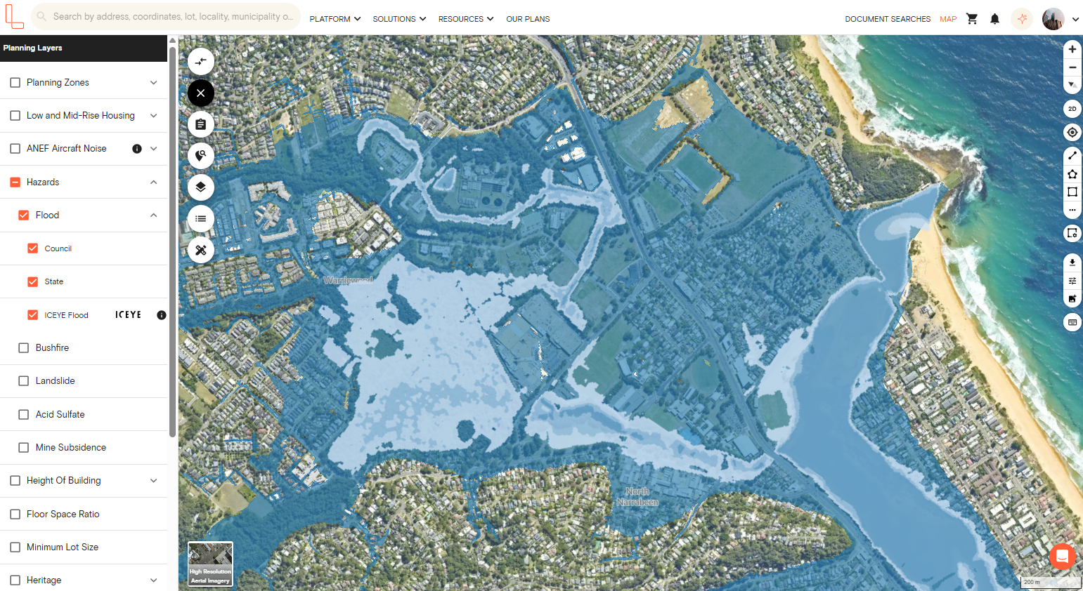
What About Sydney Flood Zones?
Sydney has highly varied flood exposure due to topography. The flood risk depends on the river catchments, waterways, and drainage systems in the densely populated areas.
Many councils, such as Blacktown, Hawkesbury, and Northern Beaches, have made efforts to understand the flood risk in their area through comprehensive flood mapping that takes into account the complexity of their river catchments.
However, the flood risk in the inner suburbs of Sydney is a totally different story. There is a risk of overland flow flooding. In some suburbs such as Marrickville, Leichhardt, and Surry Hills, the stormwater drainage system can be easily overwhelmed by the heavy rainfall, which causes flooding at the street level that is not associated with a river or a creek. These risks are hard to assess without the data from the local council.
What Flood Zones Mean for Property and Insurance in NSW
Being in a flood zone has serious financial and legal implications. Here’s what you need to be aware of:
Insurance
Properties on flood-prone land are likely to be more expensive to insure. Some insurers do not offer flood insurance policies for high-risk properties or charge unaffordable premiums.
As a result of the 2012 changes to the Insurance Contracts Act, the definition of ‘flood’ is required to be standardised, but the level of cover varies substantially between insurers. It is highly recommended to request a quote that includes coverage for the type of flood (riverine or overland flow) that is relevant to the property.
Planning and Development Controls
Council Section 10.7 Planning Certificates (previously S149) show whether a property is flood-prone. This is mandatory documentation in NSW property transactions. It will not show the level of flooding but will indicate that flood restrictions apply.
Development on flood-prone land may be regulated by development application conditions, such as minimum floor levels, flood-resistant materials, and hydraulic performance.
Floodways have the most stringent requirements, and new residential development may be prohibited altogether.
Due Diligence for Buyers
Request a Section 10.7(2) and (5) certificate (full version) to obtain all the flood information that is maintained by the council.
Compare Section 10.7 information with the flood overlay and contours on Landchecker to have an idea about the flood risk.
Compare quotes from a number of insurance companies before finalising, as the difference in premiums between insurance companies for the same property can be quite large.
What to Do if Your NSW Property is in a Flood Zone
If a NSW property sits in a flood zone, this isn't necessarily a deal-breaker. However, it requires informed and immediate action. Here are some quick tips to follow:
1. Visit or contact your local council
Councils can provide you with the flood study related to your specific property and any flood planning levels relevant to the site. Councils are required to provide this information.
2. Request multiple insurance estimates
Flood insurance can be expensive if your property is located in a flood-prone area. It’s important not to delay this process until the exchange. Having a good understanding of the insurance costs before committing gives you or your client valuable negotiating insights.
3. Add flood planning levels to your renovation or construction plans
If you’re planning to rebuild a property in NSW, adding the flood planning level, including the minimum floor height, could ensure long-term structural integrity and minimise repair costs. Adding flood planning levels might also help lower flood insurance premiums.
4. Hire a specialised flood engineer
A flood engineer can help you create data-driven reports for new developments, risk assessment, or planning applications. They can assess site-specific flood behaviour and provide you with expert advice on what’s required to meet council development requirements.
5. Review the contract of sale carefully
It’s important to have your solicitor or conveyancer review the contract of sale alongside any independent flood assessment you’ve commissioned before buying a property located in a flood-prone area. They can also provide further information and recommendations to make sure you understand any risks.
6. Consider the resale implications
When selling a property in NSW, a full legal disclosure of flood history or flood-prone status is required from the seller. This is because buyers and their legal advisors will check the documents to plan the appropriate mitigation, such as floor levels, drainage, and flood-resilient materials, to protect the property’s long-term value.
NSW Flood Zones FAQs
How do I check if my property is flood prone in NSW?
You can create a Landchecker account to check if your property is in a flood-prone area in NSW. You can also get a Section 10.7 Planning Certificate from your local council.
Do councils in NSW have different flood maps?
Yes. Since flood mapping in NSW is managed by local councils, the level of detail, method, and scope of flood mapping vary from one LGA to another. Landchecker ingests both state and local council flood data, so you can easily check what data is available for a certain property without visiting multiple websites.
What is a 1% AEP flood in NSW?
1% Annual Exceedance Probability means that there is a 1% probability that the event could occur within a given year, and is also known as the 1-in-100-year flood event.
How accurate is NSW flood mapping?
The accuracy of NSW flood mapping varies depending on the council. Those councils that have had recent and well-resourced flood studies will have high levels of detail on their maps. Meanwhile, older studies or those that cover larger rural catchments may be at a lower resolution.
Does being in a flood zone affect insurance?
Yes. Properties located in a flood zone are likely to have higher premiums, and some insurers may not offer flood insurance or may offer it with high excesses.
What does “flood planning level” mean?
Flood Planning Level (FPL) is a safety margin or the minimum height used to set floor levels in flood-prone regions. FPLs may be higher for sensitive land uses like hospitals and schools.