
Queensland Aerial Imagery 6x Higher Resolution Than Satellite
See every detail of any Queensland property with quarterly-updated aerial imagery. Track changes over time. Make confident property decisions.


See What You're Missing
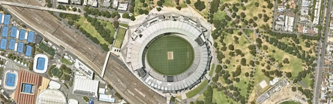
Standard satellite imagery vs. Landchecker's high resolution aerial imagery. The difference is everything when making property decisions.
Standard Satellite
What you get for free

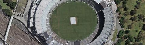
Basic Resolution
Updated once every 4 years
No historical comparison
Limited zoom capability
High Resolution Aerial Imagery
$75 /month per user

Everything from free plus:
MetroMap high-resolution aerial
Updated 4x per year (metro)
Historical timeline from 2015
Export high-res images
Trusted by thousands of businesses every day


Everything You Need for Your Property Research
Aerial imagery is just the beginning. Get comprehensive property data in one platform.


Premium Property Reports
Generate branded PDF reports with all property data for clients.

Document Search
Search public records for titles, plans ASIC searches and more


Sales History
Track historical sale prices and comparable sales in the area.


Zones & Planning
Instant access to zones, overlays, planning schemes and hazards.


Permits & Development Applications
Get notified about new planning permits and DAs in your areas of interest.


National Coverage
Access property data across all Australian states and territories.
Upgrade Today
Full access to high-resolution aerial imagery and all Standard features. No credit card required to start.
Starter
$0
Always free for users
Standard Imagery
Property boundaries
Free basic property report
Planning zones, overlays and layers
Full coverage nationally
Standard
$75 /month per user
Everything from free plus:
Uncapped current & historical High Resolution Aerial Imagery
10 Premium Property Reports p/m
Land size
Pending, approved & rejected permits/DAs
10 permit/DA Alerts
Standard Site Finder, Projects and Drawing Tools
FAQs
Why Landchecker?
Landchecker provides all your property information in one place, the property industry is fragmented with information from council, state and federal governments as well as private businesses making it difficult to find let alone navigate all these websites costing you time and money.
Our goal is simple, be the single platform that provides Australian property information in a fast, accurate and easy to use platform saving you time and money so you can get on with your analysis.
Fast:
Landchecker work hard to source the right data suppliers ensuring you have up date information so that when council or state governments make changes you see them in Landchecker ASAP
Accurate:
Landchecker takes the time to ensure the data presented is accurate and up to date and delivered in a consistent and reliable format across Australia
Easy to use:
The Landchecker map interface makes it easy to visualise property in context, What’s next door? Where is the latest development? How high are they building? Is there an Easement? Is the property in a flood area? All easily answered and visualised in Landchecker.
Which plan best suits my business?
Each of the Landchecker plans have been created to deliver value at a cost effective rate, you simply choose how many members you need and then click ‘Get Started’.
The Standard plan offers great value for an individual or a small business where 1- 3 licenses are required.
The advanced plan delivers value to businesses who require greater than 4+ members
Enterprise takes this to the next level for larger businesses with specific needs for multiple department or API requirements.
All Annual plans save you 16% or 2 months ensuring you have uncapped High Resolution Aerial Imagery as well as the latest and most accurate property information standardised across the country.
Is Landchecker available Australia wide?
Landchecker currently covers all properties across Australia, with the exception of Northern Territory. Our Team is working hard on collating the data for NT now, and it will be available within the platform soon.
Can I access a recent aerial image of my property?
To access the most recent aerial photo of your property, you can join one of our Plans here.
The High-Resolution Aerial Imagery available in our platform is sourced from our imagery provider, Metromap, who capture the images using cameras attached to planes flying at a low altitude. Imagery is captured and updated 3-4 times per year in metro areas across Australia, and 1-2 captures per year in regional areas where there is coverage.
The imagery capture are date-stamped, so you can see when the most recent image was taken and browse the historical imagery library to see past captures of the property.
If you have any questions in relation to coverage in your area, please reach out to our Support Team by emailing support@landchecker.com.au.
How do I sign-up and join a Landchecker Plan?
Visit our Plans page to join a Landchecker Plan.
While on the Plans page, you can explore the Functionality table to compare what is accessible in each of our Plans to choose which option best suits you.
Once you have chosen your plan, select Join Today.
If you do not yet have a Landchecker profile, you will be prompted to create one. If you already have a Starter Member profile you will have the option to log in, or you will be taken directly to the checkout page if you are already logged in.
To speak to a member of our Team to learn more about our Plans and how you can benefit from joining Landchecker, you can register your details with us here and a Team member will be in touch.
How do I buy a Title Search through Landchecker?
Documents can be purchased on Landchecker in two ways; directly on the Map or through the Document Searches page.
We have a range of Product Help Articles with step-by-step processes for purchasing a Title Search through the Landchecker Platform.
Purchasing a Title on the Map
Search for a property on the Map using the search bar located at the top left corner of the Map
When the Property Information Panel appears on the right-hand side of the Map, select the Documents tab
Purchasing a Title on the Document Searches page
Click on Document Searches in the navigation bar
Select the State from the Title Search tab
Select and enter the Property Identifier and select Search
How can I check easement details on Landchecker?
You can check for easements on the Landchecker Platform by selecting the Due Diligence icon on the left-hand side circle menu options, and selecting ‘Easements'. This will activate the Easements data layer over the map. Our Property Reports also indicate if there is an easement registered on a property.
Note: Easements data in Landchecker covers digitised easements only and may only represent a subset of easements on a property. The most accurate way to check for easements on a property is to purchase a copy of the Title Plan, which can be purchased through Landchecker.
Is Landchecker right for me or my business?
Landchecker is helping all members from individuals and investors right through to Enterprise firms across all stages of the property lifecycle. Landchecker is a fast, accurate and easy to use platform helping you save time reviewing all aspects of Australian property in one place.
Read more success stories from customers or review our cost effective national plans here.
Can I see a demo of the Platform prior to signing up?
Yes, you can! To schedule a demo, please register your details via this page. A member of our team will then get in touch with you to arrange a demonstration of our platform.
What documents are available through Landchecker?
Landchecker offers a variety of property documents, via direct brokerages with the authorities responsible for delivering the documents. The available documents include:
Land Title Searches and Property Documents: Access Title searches and a range of other property documents, including Title Plans, Instruments and Dealings for all properties across Victoria, New South Wales, Queensland, and South Australia.
ASIC Company Searches: Obtain ASIC company searches to get detailed information about registered companies, including their status, directors, and shareholders.
Property Information Certificates (Victoria Only): Access Property Information Certificates for all properties in Victoria, containing important land, building and planning information.
Landchecker is committed to offering competitive rates on all document searches. To speak to a member of our Team to learn more about how you can benefit from switching to Landchecker for your document search needs, please email support@landchecker.com.au.
What information is included in a property report?
Landchecker Property Reports provide a comprehensive summary of the property and surrounding area, arming you with the essentials you need to know about the property.
Information included in the reports includes detailed planning information, sales history and comparable sales, hazard layers such as bushfire and flood, and development/permit application history on the property and surrounding area.
Landchecker Property Reports offer full customisation, allowing you to choose what data is included and personalise your own front cover branding. You can learn more about our Property Reports here.
**We should have a “sample download” report attached here…
You can access unlimited Property Reports via our Advanced Plan. To discuss our Plans in more detail and learn more about how you can benefit from joining Landchecker, please contact our Team by emailing support@landchecker.com.au.
How do I check the land size of my property?
Landchecker provides the approximate land size for all properties and displays this within the platform and in our Property Reports. This data can be accessed by joining one of our paid plans, which you can view and join here.
To discuss our Plans in more detail and learn more about how you can benefit from joining Landchecker, please contact our Team by emailing support@landchecker.com.au.
Can I sign-up to a plan on a monthly term?
Landchecker Plans can be joined on a monthly or annual term, offering you flexibility to suit your needs. Annual plans include a 16% discount on the monthly price, equivalent to two months' free.
There is a toggle under the price on our Plans page, which switches the plan term between monthly and yearly. This updates the pricing accordingly.
How frequently is the data updated?
Landchecker is integrated directly with local and state government, accessing data updates daily to weekly as the data becomes available. Want more information on a particular dataset? Reach out to us at support@landchecker.com.au
How often is the High-Resolution Aerial Imagery updated on Landchecker?
High-Resolution Aerial Imagery is captured and updated 3-4 times per year in metro areas across Australia, and 1-2 captures per year in regional areas where there is coverage. This is a general guide for capture frequency, there are a number of factors that impact the ability to fly a new survey.